IMAGES TAKEN NEAR TO
Salisbury Road, SALISBURY, SP5 3JA
Introduction
This page details the photographs taken nearby to Salisbury Road, SP5 3JA by members of the Geograph project.
The Geograph project started in 2005 with the aim of publishing, organising and preserving representative images for every square kilometre of Great Britain, Ireland and the Isle of Man.

There are currently over 7.5m images from over14,400 individuals and you can help contribute to the project by visiting https://www.geograph.org.uk
Image Map (Loading...)


Getting Data...Please wait
Leaflet Map data © OpenStreetMap
Images are licensed for reuse under creativecommons.org/licenses/by-sa/2.0
Notes
- Clicking on the map will re-center to the selected point.
- The higher the marker number, the further away the image location is from the centre of the postcode.
Image Listing (10 Images Found)
Images are licensed for reuse under creativecommons.org/licenses/by-sa/2.0
Image
Details
Distance
2
Downton Brewery
The company started brewing real ale in 2003.
Image: © Maigheach-gheal
Taken: 15 Feb 2008
0.16 miles

5
Esso filling station, Salisbury Road, Downton
Image: © David Smith
Taken: 26 Jun 2013
0.19 miles
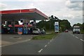
6
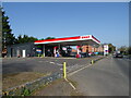
Service station on Salisbury Road
Petrol 171.9p.
Diesel 186.9p.
Image: © JThomas
Taken: 22 Mar 2022
0.19 miles
7
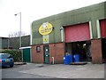
Hop Back Brewery - Downton Business Centre
Home of Summer Lightning, Crop Circle and other delicious brews.
Image: © Judith Green
Taken: 12 Mar 2007
0.21 miles
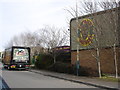
10
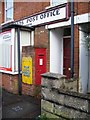
George V postbox, Downton
Located at the Crossroads Post Office.
Image: © Maigheach-gheal
Taken: 9 Nov 2008
0.25 miles