IMAGES TAKEN NEAR TO
The Ridge, SALISBURY, SP5 2LD
Introduction
This page details the photographs taken nearby to The Ridge, SP5 2LD by members of the Geograph project.
The Geograph project started in 2005 with the aim of publishing, organising and preserving representative images for every square kilometre of Great Britain, Ireland and the Isle of Man.

There are currently over 7.5m images from over14,400 individuals and you can help contribute to the project by visiting https://www.geograph.org.uk
Image Map
Images are licensed for reuse under creativecommons.org/licenses/by-sa/2.0
Notes
- Clicking on the map will re-center to the selected point.
- The higher the marker number, the further away the image location is from the centre of the postcode.
Image Listing (38 Images Found)
Images are licensed for reuse under creativecommons.org/licenses/by-sa/2.0
Image
Details
Distance
1
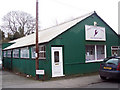
Forest School of Dance and Theatre Arts
Image: © Maigheach-gheal
Taken: 15 Jan 2007
0.10 miles
2
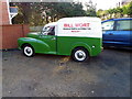
Morris Minor van, Morgan's Vale
The van is in the yard of a small garage in the village.
Image: © Maigheach-gheal
Taken: 3 Feb 2011
0.10 miles

6
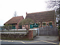
Morgan's Vale and Woodfalls CE VA Primary School
Image: © Maigheach-gheal
Taken: 15 Jan 2007
0.12 miles
7
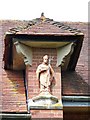
Statue of St Birinus
A hipped gablet with niche and statue of St Birinus. For a view of the church Image
St Birinus was a Benedictine monk from the monastery of St Andrew in Rome. St Birinus came to England in 634 and he died on 3rd December 650. His feast day is celebrated on 5th December.
Image: © Maigheach-gheal
Taken: 25 Apr 2010
0.12 miles
8
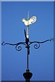
Weather vane, Church of St Birinus
The word 'vane' comes from the Anglo-Saxon word 'fane', meaning 'flag'. Originally, fabric pennants would show archers the direction of the wind. Later, the cloth flags were replaced by metal ones, decorated with the nobleman's coat of arms. It was understood that shifts in the wind often indicated changes in the weather. Cardinal points were not added until several centuries later.
Weather vanes have always been more than just a wind direction device. Created by skilled craftsman, there is true artistic expression in the varied designs. Initially wood vanes were carved by carpenters or furniture makers, and iron, copper and tin ones were forged by the local blacksmith or tinsmith. In the 19th century weather vanes started to be mass-produced from moulds.
Image: © Maigheach-gheal
Taken: 25 Apr 2010
0.12 miles
9
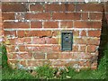
Flush Bracket S9675, Church of St Birinus
The plate is on the south-east wall of the church Image and http://www.bench-marks.org.uk/bm21654
A bench mark is an Ordnance Survey arrowhead sign found on walls, bridges, churches and specially erected triangulation pillars where the altitude above sea-level has been accurately measured by surveyors. The arrowhead points to a horizontal line above it which marks the exact altitude.
With rivets and pivots there is no datum (horizontal line) cut, the pointed-to horizontal surface defining the datum height.
Image: © Maigheach-gheal
Taken: 25 Apr 2010
0.12 miles
10
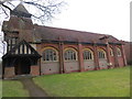
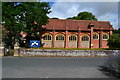
The Church of St Brinus at Morgan's Vale
Viewed from the south.
Image: © Peter Wood
Taken: 14 Feb 2017
0.12 miles