IMAGES TAKEN NEAR TO
Bowers Hill, SALISBURY, SP5 2HD
Introduction
This page details the photographs taken nearby to Bowers Hill, SP5 2HD by members of the Geograph project.
The Geograph project started in 2005 with the aim of publishing, organising and preserving representative images for every square kilometre of Great Britain, Ireland and the Isle of Man.

There are currently over 7.5m images from over14,400 individuals and you can help contribute to the project by visiting https://www.geograph.org.uk
Image Map
Images are licensed for reuse under creativecommons.org/licenses/by-sa/2.0
Notes
- Clicking on the map will re-center to the selected point.
- The higher the marker number, the further away the image location is from the centre of the postcode.
Image Listing (40 Images Found)
Images are licensed for reuse under creativecommons.org/licenses/by-sa/2.0
Image
Details
Distance
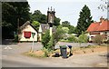
2
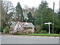
Lodge to Redlynch House
A grade II listed building, 1820, enlarged 1860.
Image: © Robin Webster
Taken: 18 Dec 2015
0.07 miles
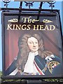
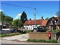
5
The Kings Head pub and sign Redlynch
It is also dustbin day !
Image: © roger geach
Taken: 1 Jul 2010
0.08 miles
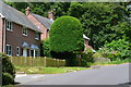
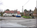
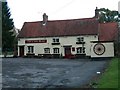
6
The King's Head public house, Redlynch
Image: © David Martin
Taken: 15 Jun 2018
0.09 miles
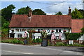
8
The Kings Head
The unattractive 'tent' outside this pub disguises its early 18th C origins. Nevertheless it is Grade II listed with English Heritage Building ID: 319754.
Image: © Stuart Logan
Taken: 29 Jan 2013
0.09 miles
10
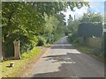
Princes Hill
Boundary sign for entering the New Forest.
Web : https://en.wikipedia.org/wiki/New_Forest
Image: © James Emmans
Taken: 24 Sep 2023
0.09 miles