IMAGES TAKEN NEAR TO
Forest Road, SALISBURY, SP5 2BW
Introduction
This page details the photographs taken nearby to Forest Road, SP5 2BW by members of the Geograph project.
The Geograph project started in 2005 with the aim of publishing, organising and preserving representative images for every square kilometre of Great Britain, Ireland and the Isle of Man.

There are currently over 7.5m images from over14,400 individuals and you can help contribute to the project by visiting https://www.geograph.org.uk
Image Map
Images are licensed for reuse under creativecommons.org/licenses/by-sa/2.0
Notes
- Clicking on the map will re-center to the selected point.
- The higher the marker number, the further away the image location is from the centre of the postcode.
Image Listing (36 Images Found)
Images are licensed for reuse under creativecommons.org/licenses/by-sa/2.0
Image
Details
Distance
1
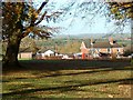
Nomansland
Looking towards the village main road from the other side of the cricket pitch
Image: © Gillian Thomas
Taken: 23 Nov 2006
0.02 miles
2
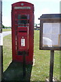
Nomansland: postbox № SP5 326 and phone
Nomansland gets its name no doubt from the fact that it stands right on the border of Hampshire and Wiltshire. These two red objects seemingly stand right on the boundary, if anything perhaps just in Hampshire, matching the road through the village. However, the noticeboard is of Redlynch Parish Council which is the Wiltshire side, perhaps more relevant to the residents since the houses are certainly in Wiltshire, being set back somewhat from the road or in side-roads on that western side.
The postbox is emptied at 4:30pm on weekdays and at 9:30am on Saturdays.
Image: © Chris Downer
Taken: 21 May 2011
0.04 miles
3
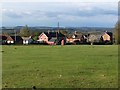
Village Green, Nomansland
Looking north from the car park opposite the Lamb public house
Image: © David Martin
Taken: 16 Apr 2009
0.06 miles
4
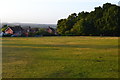
Evening view across the green at Nomansland
Image: © David Martin
Taken: 21 Jun 2020
0.08 miles
5
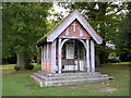
The Well of Sacrifice, Nomansland, New Forest
On the village green, close to the cricket pitch, is this unusual memorial to the local men who served in the 1914-18 and 1939-45 conflicts. The structure is apparently on top of a well. It is curious that the name of the village, Nomansland, is the same as that famously used in the trench warfare of the 1914-18 war.
Image: © Jim Champion
Taken: 1 Oct 2005
0.08 miles
6
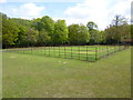
Nomansland, cricket pitch
Like other New Forest village pitches, the crease is fenced off, to prevent damage from livestock: http://www.nomanslandcricketclub.net/club.html
Image: © Mike Faherty
Taken: 4 May 2014
0.08 miles
7
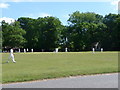
Nomansland: cricket match on the village green
A quintessential English village scene on a beautifully sunny day.
Image: © Chris Downer
Taken: 21 May 2011
0.09 miles
8
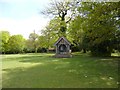
Nomansland, Well of Sacrifice
War memorial on the village green, listing men fallen in WWI (10) and WWII (6), and, unusually, those serving in both wars.
Image: © Mike Faherty
Taken: 4 May 2014
0.10 miles
9
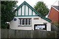
Nomansland, Hampshire
Nomansland Reading Room. Built in 1910 on land donated by the Revd. H M Livens. The plaque displaying this information may be seen here: Image
Image: © Brendan and Ruth McCartney
Taken: 24 Jun 2011
0.10 miles
10
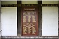
Nomansland, Hampshire
The plaque displayed in the Well of Sacrifice War Memorial in the village.
Image: © Brendan and Ruth McCartney
Taken: 24 Jun 2011
0.11 miles