IMAGES TAKEN NEAR TO
Wains Way, SALISBURY, SP4 9RU
Introduction
This page details the photographs taken nearby to Wains Way, SP4 9RU by members of the Geograph project.
The Geograph project started in 2005 with the aim of publishing, organising and preserving representative images for every square kilometre of Great Britain, Ireland and the Isle of Man.

There are currently over 7.5m images from over14,400 individuals and you can help contribute to the project by visiting https://www.geograph.org.uk
Image Map
Images are licensed for reuse under creativecommons.org/licenses/by-sa/2.0
Notes
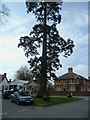
- Clicking on the map will re-center to the selected point.
- The higher the marker number, the further away the image location is from the centre of the postcode.
Image Listing (132 Images Found)
Images are licensed for reuse under creativecommons.org/licenses/by-sa/2.0
Image
Details
Distance
1
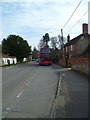
The Orange Way in Wiltshire (272)
This is looking south on Netheravon High Street and here comes my bus.
To proceed to the next section of the Orange Way go to www.geograph.org.uk/geotrips/570.
Image: © Shazz
Taken: 24 Apr 2013
0.06 miles
2
The Orange Way in Wiltshire (271)
Here's a triangle of green between High Street and Lower Road in Netheravon.
Image: © Shazz
Taken: 24 Apr 2013
0.07 miles
3
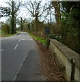
The Orange Way in Wiltshire (269)
This is yet another crossing of the River Avon on the way to Netheravon.
Image: © Shazz
Taken: 24 Apr 2013
0.08 miles
4
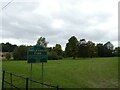
Millennium Park, Netheravon: September 2024
Image: © Basher Eyre
Taken: 10 Sep 2024
0.10 miles
5
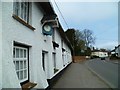
The Orange Way in Wiltshire (273)
This cottage on Netheravon High Street has a clock showing the right time.
Image: © Shazz
Taken: 25 Apr 2013
0.12 miles
6
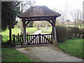
Lych gate, All Saints Church, Netheravon
Many churches have a lych gate built over the main entrance to the enclosed area round the church. The name, also spelt lich or lytch, is from the Anglo Saxon 'lich' meaning corpse. The gate marks the division between consecrated and unconsecrated ground, where the bearers sheltered with the coffin, waiting for the clergyman to lead the procession before the burial.
Image: © Maigheach-gheal
Taken: 11 Mar 2007
0.13 miles
7
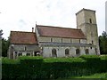
![Parish church [6]](https://s1.geograph.org.uk/geophotos/06/38/95/6389569_a13fffbf_120x120.jpg)
Parish church [6]
The churchyard has many old tombs and grave markers.
The church of All Saints has parts from the 11th, 12th 13th and 15th centuries and was restored in 1889. The lower part of the west tower is 11th century, the nave and chancel are 13th century and the aisles were rebuilt in the 15th century. Restoration included replacement of the roofs and chancel arch and demolition of the north porch. The site is that of a Saxon church, recorded in the Domesday survey of 1086. Listed, grade I, with details at: https://historicengland.org.uk/listing/the-list/list-entry/1033956
Image: © Michael Dibb
Taken: 31 Dec 2019
0.14 miles
8
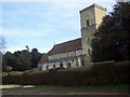
All Saints Church, Netheravon
The large flint rubble tower is a remnant of a central tower to a Saxon-Norman building. Much of the rest of the building is Early English in style.
Image: © Maigheach-gheal
Taken: 11 Mar 2007
0.14 miles
9
All Saints C of E Aided Primary School
Image: © Maigheach-gheal
Taken: 11 Mar 2007
0.14 miles
10
All Saints Church, Netheravon
The large flint rubble tower is a remnant of a central tower to a Saxon-Norman building. Much of the rest of the building is Early English in style.
Image: © Maigheach-gheal
Taken: 6 Jun 2010
0.14 miles