IMAGES TAKEN NEAR TO
Kennel Row, SALISBURY, SP4 9RH
Introduction
This page details the photographs taken nearby to Kennel Row, SP4 9RH by members of the Geograph project.
The Geograph project started in 2005 with the aim of publishing, organising and preserving representative images for every square kilometre of Great Britain, Ireland and the Isle of Man.

There are currently over 7.5m images from over14,400 individuals and you can help contribute to the project by visiting https://www.geograph.org.uk
Image Map
Images are licensed for reuse under creativecommons.org/licenses/by-sa/2.0
Notes
- Clicking on the map will re-center to the selected point.
- The higher the marker number, the further away the image location is from the centre of the postcode.
Image Listing (130 Images Found)
Images are licensed for reuse under creativecommons.org/licenses/by-sa/2.0
Image
Details
Distance
1
The Orange Way in Wiltshire (271)
Here's a triangle of green between High Street and Lower Road in Netheravon.
Image: © Shazz
Taken: 24 Apr 2013
0.04 miles
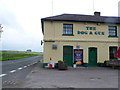
3
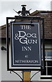
Sign for the Dog & Gun, Netheravon
See Image] for context.
Image: © JThomas
Taken: 13 Jul 2019
0.05 miles
4
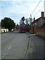
The Orange Way in Wiltshire (272)
This is looking south on Netheravon High Street and here comes my bus.
To proceed to the next section of the Orange Way go to www.geograph.org.uk/geotrips/570.
Image: © Shazz
Taken: 24 Apr 2013
0.05 miles
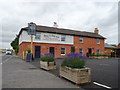
5
Dog and Gun Fish and Chips. Netheravon
This photo was taken about a month after the pub had been taken over and it now seems to be operating like a fish and chip shop with beer! A different way indeed to revive the pub trade.
Image: © Nigel Mykura
Taken: 23 Jun 2013
0.05 miles
6
The Dog & Gun, Netheravon
On Salisbury Road.
Refurbished since 2013 Image]
Image: © JThomas
Taken: 13 Jul 2019
0.05 miles
7
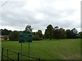
Millennium Park, Netheravon: September 2024
Image: © Basher Eyre
Taken: 10 Sep 2024
0.06 miles
8
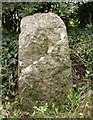
Old Milestone by A345, Salisbury Road junction, Netheravon
Carved stone post by the UC road, in parish of NETHERAVON (KENNET District), Minor road to Manor Farm at junction with the A345, on the verge, on South side of road. Erected by the Amesbury turnpike trust in the 19th century.
Inscription is illegible.
Grade II listed.
List Entry Number: 1033920 https://historicengland.org.uk/listing/the-list/list-entry/1033920
Milestone Society National ID: WI_NEDZ00.
Image: © M Faherty
Taken: 27 Oct 2007
0.07 miles

10
A345 Salisbury Road, Netheravon
Heading north.
Image: © Robin Webster
Taken: 2 Feb 2018
0.10 miles