IMAGES TAKEN NEAR TO
Netheravon, SALISBURY, SP4 9RG
Introduction
This page details the photographs taken nearby to SP4 9RG by members of the Geograph project.
The Geograph project started in 2005 with the aim of publishing, organising and preserving representative images for every square kilometre of Great Britain, Ireland and the Isle of Man.

There are currently over 7.5m images from over14,400 individuals and you can help contribute to the project by visiting https://www.geograph.org.uk
Image Map
Images are licensed for reuse under creativecommons.org/licenses/by-sa/2.0
Notes
- Clicking on the map will re-center to the selected point.
- The higher the marker number, the further away the image location is from the centre of the postcode.
Image Listing (28 Images Found)
Images are licensed for reuse under creativecommons.org/licenses/by-sa/2.0
Image
Details
Distance
1
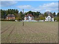
Farmland and houses, Netheravon
Looking towards Wexland Avenue from the road at Manor Farm.
Image: © Andrew Smith
Taken: 15 Apr 2012
0.14 miles
2
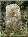
Old Milestone by A345, Salisbury Road junction, Netheravon
Carved stone post by the UC road, in parish of NETHERAVON (KENNET District), Minor road to Manor Farm at junction with the A345, on the verge, on South side of road. Erected by the Amesbury turnpike trust in the 19th century.
Inscription is illegible.
Grade II listed.
List Entry Number: 1033920 https://historicengland.org.uk/listing/the-list/list-entry/1033920
Milestone Society National ID: WI_NEDZ00.
Image: © M Faherty
Taken: 27 Oct 2007
0.16 miles
4
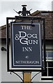
Sign for the Dog & Gun, Netheravon
See Image] for context.
Image: © JThomas
Taken: 13 Jul 2019
0.19 miles
5
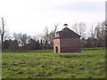
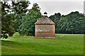
Dovecote near All Saints Church, Netheravon
Dovecote built in the 18th century of brick with a tile roof. Restored in 1980. Still with most of its 700 nesting boxes.
Image: © Maigheach-gheal
Taken: 11 Mar 2007
0.19 miles
6
![Netheravon House [3]](https://s1.geograph.org.uk/geophotos/06/39/01/6390181_18f85dd8_120x120.jpg)
Netheravon House [3]
The Dovecote is seen from the churchyard. Listed, grade II, with details at: https://historicengland.org.uk/listing/the-list/list-entry/1033902
The house was built circa 1740 as a villa and hunting box for the Duke of Beaufort and extended in 1791. There was probably an earlier building on the site and possibly a Roman villa. The War Department purchased the house and stables in 1898 and it was the home of the Cavalry School from 1904. Later the house served as the Officers' Mess for the School of Infantry. Sold by the Ministry of Defence in the late 1990s, the house was converted in 2004 into two homes and the stables into seven. There is an 18th century dovecote, restored circa 1980, in the grounds.
Image: © Michael Dibb
Taken: 31 Dec 2019
0.20 miles
7
![Netheravon House [4]](https://s2.geograph.org.uk/geophotos/06/39/01/6390182_0245bbb6_120x120.jpg)
Netheravon House [4]
The Dovecote is seen from the approach lane to the church. Listed, grade II, with details at: https://historicengland.org.uk/listing/the-list/list-entry/1033902
The house was built circa 1740 as a villa and hunting box for the Duke of Beaufort and extended in 1791. There was probably an earlier building on the site and possibly a Roman villa. The War Department purchased the house and stables in 1898 and it was the home of the Cavalry School from 1904. Later the house served as the Officers' Mess for the School of Infantry. Sold by the Ministry of Defence in the late 1990s, the house was converted in 2004 into two homes and the stables into seven. There is an 18th century dovecote, restored circa 1980, in the grounds.
Image: © Michael Dibb
Taken: 31 Dec 2019
0.20 miles
8
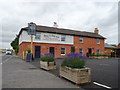
The Dog & Gun, Netheravon
On Salisbury Road.
Refurbished since 2013 Image]
Image: © JThomas
Taken: 13 Jul 2019
0.20 miles
9
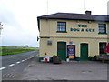
Dog and Gun Fish and Chips. Netheravon
This photo was taken about a month after the pub had been taken over and it now seems to be operating like a fish and chip shop with beer! A different way indeed to revive the pub trade.
Image: © Nigel Mykura
Taken: 23 Jun 2013
0.20 miles