IMAGES TAKEN NEAR TO
Old Coach Road, SALISBURY, SP4 9DA
Introduction
This page details the photographs taken nearby to Old Coach Road, SP4 9DA by members of the Geograph project.
The Geograph project started in 2005 with the aim of publishing, organising and preserving representative images for every square kilometre of Great Britain, Ireland and the Isle of Man.

There are currently over 7.5m images from over14,400 individuals and you can help contribute to the project by visiting https://www.geograph.org.uk
Image Map
Images are licensed for reuse under creativecommons.org/licenses/by-sa/2.0
Notes
- Clicking on the map will re-center to the selected point.
- The higher the marker number, the further away the image location is from the centre of the postcode.
Image Listing (32 Images Found)
Images are licensed for reuse under creativecommons.org/licenses/by-sa/2.0
Image
Details
Distance
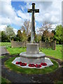
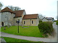
1
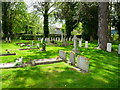
Bulford - Graveyard
As well as civilian graves this graveyard is the resting place of many Commonwealth soldiers from both world wars.
Image: © Chris Talbot
Taken: 25 Apr 2009
0.06 miles
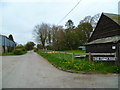
2
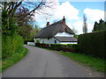
Bulford - Old Coach Road
Old Coach Road Bulford
Image: © Chris Talbot
Taken: 25 Apr 2009
0.06 miles
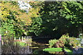
4
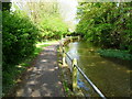
Bulford - Riverside Walk
About halfway along this walk alongside the Avon.
Image: © Chris Talbot
Taken: 25 Apr 2009
0.08 miles
6
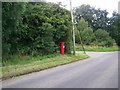
Pillar box near Bulford
A George V pillar box on the outskirts of the village of Bulford.
Image: © Maigheach-gheal
Taken: 3 Aug 2009
0.10 miles
7
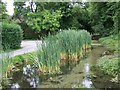
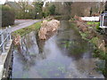
Nine Mile River, Bulford
Nine Mile river isn’t nine miles long but is thought to have been so named as carters reckoned it was nine miles to Salisbury when they reached it!
Image: © Maigheach-gheal
Taken: 25 Jul 2008
0.11 miles
8
Bulford - War Memorial
Bulfords memorial to her fallen.
Image: © Chris Talbot
Taken: 25 Apr 2009
0.12 miles
9
The Orange Way in Wiltshire (240)
Church Lane heads out of Bulford.
Image: © Shazz
Taken: 24 Apr 2013
0.12 miles
10
The Orange Way in Wiltshire (239)
Church Lane is taken, passing the church on the left.
Image: © Shazz
Taken: 24 Apr 2013
0.13 miles