IMAGES TAKEN NEAR TO
Milston Road, SALISBURY, SP4 9BY
Introduction
This page details the photographs taken nearby to Milston Road, SP4 9BY by members of the Geograph project.
The Geograph project started in 2005 with the aim of publishing, organising and preserving representative images for every square kilometre of Great Britain, Ireland and the Isle of Man.

There are currently over 7.5m images from over14,400 individuals and you can help contribute to the project by visiting https://www.geograph.org.uk
Image Map
Images are licensed for reuse under creativecommons.org/licenses/by-sa/2.0
Notes
- Clicking on the map will re-center to the selected point.
- The higher the marker number, the further away the image location is from the centre of the postcode.
Image Listing (6 Images Found)
Images are licensed for reuse under creativecommons.org/licenses/by-sa/2.0
Image
Details
Distance
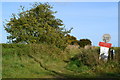
1
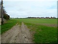
The Orange Way in Wiltshire (241)
Church Lane has become a path and entered a field. The view is towards the houses on Milston Road.
Image: © Shazz
Taken: 24 Apr 2013
0.02 miles
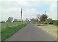
4
The Orange Way in Wiltshire (242)
Another stile, another field. The stile sports a waymark for PAT (the Pewsey Avon Trail).
Image: © Shazz
Taken: 24 Apr 2013
0.14 miles
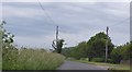
5
Track for military vehicles below 10 tons
Although it does not look to have been used for a long time.
Image: © David Martin
Taken: 25 Oct 2015
0.19 miles
6
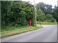
Pillar box near Bulford
A George V pillar box on the outskirts of the village of Bulford.
Image: © Maigheach-gheal
Taken: 3 Aug 2009
0.22 miles