IMAGES TAKEN NEAR TO
Armitage Square, SALISBURY, SP4 8NS
Introduction
This page details the photographs taken nearby to Armitage Square, SP4 8NS by members of the Geograph project.
The Geograph project started in 2005 with the aim of publishing, organising and preserving representative images for every square kilometre of Great Britain, Ireland and the Isle of Man.

There are currently over 7.5m images from over14,400 individuals and you can help contribute to the project by visiting https://www.geograph.org.uk
Image Map
Images are licensed for reuse under creativecommons.org/licenses/by-sa/2.0
Notes
- Clicking on the map will re-center to the selected point.
- The higher the marker number, the further away the image location is from the centre of the postcode.
Image Listing (6 Images Found)
Images are licensed for reuse under creativecommons.org/licenses/by-sa/2.0
Image
Details
Distance
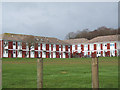
2
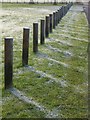
Frost shadows, Larkhill
Frost remains where the post has cast a shadow. This is on Willoughby Road, on the southwest fringe of Larkhill.
Image: © Derek Harper
Taken: 11 Dec 2009
0.06 miles
3
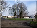
Road junction, Larkhill
Willoughby Road (left, ahead) meets Fargo Road (right). Image was taken just up the former. Beyond is the housing shown in Image
Image: © Derek Harper
Taken: 11 Dec 2009
0.08 miles
4
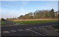
Crossroads, Larkhill
Bingham Road (where the photographer is standing) crosses Willoughby Road at the western edge of the built-up area.
Image: © Derek Harper
Taken: 11 Dec 2009
0.12 miles
5
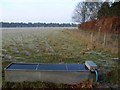
Water trough, Durrington Down
Frosty tracks lead to and from the trough beside the byway between Larkhill and Stonehenge.
Image: © Derek Harper
Taken: 11 Dec 2009
0.23 miles
6
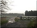
Byway on Durrington Down
The byway, which continues the line of Willoughby Road south of Larkhill, approaches two conifer plantations. Taken from the same spot as Image
Image: © Derek Harper
Taken: 11 Dec 2009
0.24 miles