IMAGES TAKEN NEAR TO
Wells Road, SALISBURY, SP4 8LT
Introduction
This page details the photographs taken nearby to Wells Road, SP4 8LT by members of the Geograph project.
The Geograph project started in 2005 with the aim of publishing, organising and preserving representative images for every square kilometre of Great Britain, Ireland and the Isle of Man.

There are currently over 7.5m images from over14,400 individuals and you can help contribute to the project by visiting https://www.geograph.org.uk
Image Map
Images are licensed for reuse under creativecommons.org/licenses/by-sa/2.0
Notes
- Clicking on the map will re-center to the selected point.
- The higher the marker number, the further away the image location is from the centre of the postcode.
Image Listing (23 Images Found)
Images are licensed for reuse under creativecommons.org/licenses/by-sa/2.0
Image
Details
Distance
1
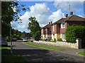
Wells Road, Larkhill
On an estate of identical detached houses marked on the map as being married quarters.
Image: © Andrew Smith
Taken: 8 Jul 2007
0.05 miles
3
Cuckoo Stone plaque on gatepost
Also seen at http://www.geograph.org.uk/photo/2147016 in 2010.
Image: © Shazz
Taken: 12 Sep 2014
0.10 miles
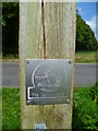
4
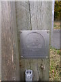
Plaque on gatepost
Commemorative plaque on the inside of roadside gatepost near Strangeways.
The Cuckoo Stone is on NT owned land. Gate gives access to permissive path.
Image: © Liz Stone
Taken: 3 Nov 2010
0.12 miles
5
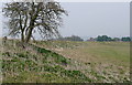
Durrington Walls
Looking north along the western banks of Durrington Walls. This is a huge earth banked circle, far larger than the more famous nearby Stonehenge or Woodhenge. It is thought to have housed a Neolithic settlement of a few thousand people, the largest of its kind in North-West Europe. It features an avenue aligned to the winter solstice and is believed to have been a complementary site to the earliest phases of Stonehenge. One theory is that the Stonehenge users lived here, and the link between them along the River Avon represents the transition from life to death.
Image: © Graham Horn
Taken: 26 Mar 2011
0.12 miles
6
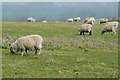
Sheep at Durrington
In the area around the ancient Durrington Walls is pasture downland. There are so many people visiting the walls that the sheep are obvious and do not run away as they would do in less frequented areas.
Image: © Graham Horn
Taken: 26 Mar 2011
0.13 miles
7
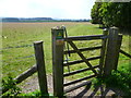
Looking into Cuckoo Stone Field
The gate has a handy grid reference!
Image: © Shazz
Taken: 12 Sep 2014
0.13 miles
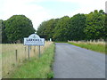
8
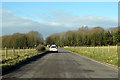
Road towards Larkhill
Apparently favoured for driving instruction.
Image: © Robin Webster
Taken: 2 Feb 2018
0.16 miles
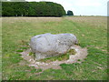
9
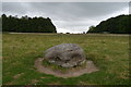
The Cuckoo Stone
The Cuckoo Stone is a Neolithic or Bronze Age standing stone. The stone, which is now fallen, is in a field near to Woodhenge and Durrington Walls in Wiltshire, England (grid reference SU14654335). It is part of the wider Stonehenge Landscape. https://en.wikipedia.org/wiki/Cuckoo_Stone
Image: © Phil Champion
Taken: 12 Sep 2017
0.16 miles