IMAGES TAKEN NEAR TO
Wells Road, SALISBURY, SP4 8LS
Introduction
This page details the photographs taken nearby to Wells Road, SP4 8LS by members of the Geograph project.
The Geograph project started in 2005 with the aim of publishing, organising and preserving representative images for every square kilometre of Great Britain, Ireland and the Isle of Man.

There are currently over 7.5m images from over14,400 individuals and you can help contribute to the project by visiting https://www.geograph.org.uk
Image Map
Images are licensed for reuse under creativecommons.org/licenses/by-sa/2.0
Notes
- Clicking on the map will re-center to the selected point.
- The higher the marker number, the further away the image location is from the centre of the postcode.
Image Listing (17 Images Found)
Images are licensed for reuse under creativecommons.org/licenses/by-sa/2.0
Image
Details
Distance
1
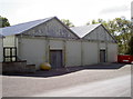
No disguise
These industrial buildings have not changed materially since their construction. A casual glance will confirm they are in fact aircraft hangars, and historically were part of the foundation of military flight around the time of the Great War. Originally part of the Royal Engineers, the early use of flying machines soon brought about the formation of a dedicated air force - the Royal Flying Corps. Fundamental to the creation at this time were a collection of notable institutions, including schools and the founding of the British and Colonial Aeroplane Company in 1910 by Bristol industrialist Sir George White. He rented some of these hangars.
Further to the north are the last remains of some other hangars, albeit almost covered by vegetation - see Image
Image: © Neil Owen
Taken: 19 Sep 2012
0.11 miles
2
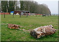
Stables at Strangways
These are probably part of the adjacent military housing area. To the right is downland pasture.
Image: © Graham Horn
Taken: 26 Mar 2011
0.13 miles
3
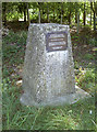
Little acorns...
Memorial stone on Wood Road. The inscription reads:
'On this site the first aerodrome for the army was founded in 1910 by Capt. J.D.B. Fulton RFA and Mr G.B. Cockburn
This later became 2' Coy Air Bn RE
The British and Colonial Aeroplane Company forerunners of the Bristol Aeroplane Company established their flying school here in 1910
The first military air trials were held here in 1912.'
Image: © Neil Owen
Taken: 19 Sep 2012
0.14 miles
4
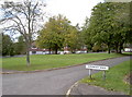
Goodbody Road
A small crescent in amongst the old military area of Larkhill.
Image: © Neil Owen
Taken: 19 Sep 2012
0.15 miles
5
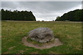
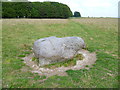
The Cuckoo Stone
The Cuckoo Stone is a Neolithic or Bronze Age standing stone. The stone, which is now fallen, is in a field near to Woodhenge and Durrington Walls in Wiltshire, England (grid reference SU14654335). It is part of the wider Stonehenge Landscape. https://en.wikipedia.org/wiki/Cuckoo_Stone
Image: © Phil Champion
Taken: 12 Sep 2017
0.16 miles
6
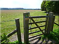
Looking into Cuckoo Stone Field
The gate has a handy grid reference!
Image: © Shazz
Taken: 12 Sep 2014
0.16 miles
8
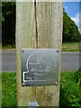
Cuckoo Stone plaque on gatepost
Also seen at http://www.geograph.org.uk/photo/2147016 in 2010.
Image: © Shazz
Taken: 12 Sep 2014
0.16 miles
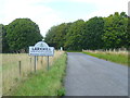
10
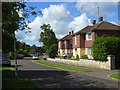
Wells Road, Larkhill
On an estate of identical detached houses marked on the map as being married quarters.
Image: © Andrew Smith
Taken: 8 Jul 2007
0.16 miles