IMAGES TAKEN NEAR TO
Figheldean, SALISBURY, SP4 8LB
Introduction
This page details the photographs taken nearby to SP4 8LB by members of the Geograph project.
The Geograph project started in 2005 with the aim of publishing, organising and preserving representative images for every square kilometre of Great Britain, Ireland and the Isle of Man.

There are currently over 7.5m images from over14,400 individuals and you can help contribute to the project by visiting https://www.geograph.org.uk
Image Map
Images are licensed for reuse under creativecommons.org/licenses/by-sa/2.0
Notes
- Clicking on the map will re-center to the selected point.
- The higher the marker number, the further away the image location is from the centre of the postcode.
Image Listing (9 Images Found)
Images are licensed for reuse under creativecommons.org/licenses/by-sa/2.0
Image
Details
Distance
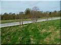
1
The Orange Way in Wiltshire (257)
The path crosses the drive to Syrencot House.
Image: © Shazz
Taken: 24 Apr 2013
0.13 miles
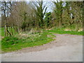
2
The Orange Way in Wiltshire (256)
The path crosses a military road.
Image: © Shazz
Taken: 24 Apr 2013
0.18 miles
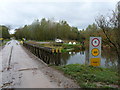
3
Milston Ford
This ford on the River Avon at Milston is used by the military.
Image: © John Walton
Taken: 23 Jan 2016
0.18 miles
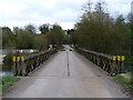
5
Milston - Bailey Bridge
Bailey bridge crossing the river Avon.
Image: © Chris Talbot
Taken: 1 Nov 2009
0.20 miles
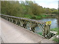
6
Milston - Bailey Bridge
Looking across the bailey bridge that crosses the River Avon.
Image: © Chris Talbot
Taken: 1 Nov 2009
0.20 miles
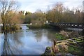
7
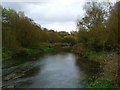
Milston - The River Avon
The River Avon at Milson.
Image: © Chris Talbot
Taken: 1 Nov 2009
0.20 miles
8
Milston - Ford
The ford across the River Avon.
Image: © Chris Talbot
Taken: 1 Nov 2009
0.20 miles
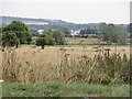
9
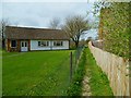
The Orange Way in Wiltshire (255)
This path between dwellings leads to a field.
Image: © Shazz
Taken: 24 Apr 2013
0.25 miles