IMAGES TAKEN NEAR TO
Robin Hill Lane, SALISBURY, SP4 8DN
Introduction
This page details the photographs taken nearby to Robin Hill Lane, SP4 8DN by members of the Geograph project.
The Geograph project started in 2005 with the aim of publishing, organising and preserving representative images for every square kilometre of Great Britain, Ireland and the Isle of Man.

There are currently over 7.5m images from over14,400 individuals and you can help contribute to the project by visiting https://www.geograph.org.uk
Image Map
Images are licensed for reuse under creativecommons.org/licenses/by-sa/2.0
Notes
- Clicking on the map will re-center to the selected point.
- The higher the marker number, the further away the image location is from the centre of the postcode.
Image Listing (13 Images Found)
Images are licensed for reuse under creativecommons.org/licenses/by-sa/2.0
Image
Details
Distance
3
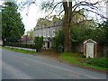
Bulford - Bulford Manor
An impressive house located opposite St Leonard's church.
Image: © Chris Talbot
Taken: 25 Apr 2009
0.20 miles
4
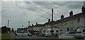
Bus stop, pharmacist and electricity pole, Bulford Road, Durrington
The road is named Bulford Road and classified as the B3085. Durrington is a small town with strong military connections. It is close to Bulford Camp, still an active Army installation.
Image: © Brian Robert Marshall
Taken: 12 Apr 2011
0.21 miles
5
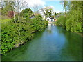
Bulford - The River Avon
The River Avon meanders through Bulford.
Image: © Chris Talbot
Taken: 25 Apr 2009
0.21 miles
6
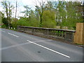
Bulford - Bridge Over The River Avon
This bridge carries the road between Bulford and Durrington over the River Avon.
Image: © Chris Talbot
Taken: 25 Apr 2009
0.21 miles
7
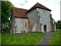
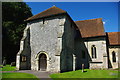
Bulford - St Leonards Church
A church has stood on this site since the 12thC with the chancel arch and three of the walls still surviving from that era.
Image: © Chris Talbot
Taken: 25 Apr 2009
0.24 miles
8
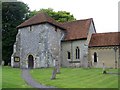
Bulford - St Leonards Church
The building of a three stage tower to the church on poor foundations, led to the top stage being removed in the 16thC, leaving the rather squat tower that remains today.
Image: © Chris Talbot
Taken: 25 Apr 2009
0.24 miles
10
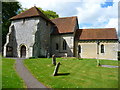
St Leonard's Church, Bulford
A church stood here by the early 12th century and probably belonged to Amesbury Abbey. It was certainly confirmed as belonging to Amesbury Priory in 1179 and the priors appointed chaplains here until the Dissolution.
Image: © Maigheach-gheal
Taken: 25 Jul 2008
0.25 miles