IMAGES TAKEN NEAR TO
Hackthorne Road, SALISBURY, SP4 8AS
Introduction
This page details the photographs taken nearby to Hackthorne Road, SP4 8AS by members of the Geograph project.
The Geograph project started in 2005 with the aim of publishing, organising and preserving representative images for every square kilometre of Great Britain, Ireland and the Isle of Man.

There are currently over 7.5m images from over14,400 individuals and you can help contribute to the project by visiting https://www.geograph.org.uk
Image Map
Images are licensed for reuse under creativecommons.org/licenses/by-sa/2.0
Notes
- Clicking on the map will re-center to the selected point.
- The higher the marker number, the further away the image location is from the centre of the postcode.
Image Listing (11 Images Found)
Images are licensed for reuse under creativecommons.org/licenses/by-sa/2.0
Image
Details
Distance
10
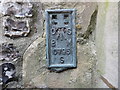
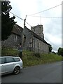
Ordnance Survey Flush Bracket S0795
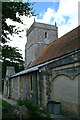
This can be found on the wall of All Saints Church at Durrington.
For more detail see : http://www.bench-marks.org.uk/bm20522
Image: © Peter Wood
Taken: 24 Mar 2015
0.22 miles