IMAGES TAKEN NEAR TO
Maple Way, SALISBURY, SP4 7WE
Introduction
This page details the photographs taken nearby to Maple Way, SP4 7WE by members of the Geograph project.
The Geograph project started in 2005 with the aim of publishing, organising and preserving representative images for every square kilometre of Great Britain, Ireland and the Isle of Man.

There are currently over 7.5m images from over14,400 individuals and you can help contribute to the project by visiting https://www.geograph.org.uk
Image Map (Loading...)


Getting Data...Please wait
Leaflet Map data © OpenStreetMap
Images are licensed for reuse under creativecommons.org/licenses/by-sa/2.0
Notes
- Clicking on the map will re-center to the selected point.
- The higher the marker number, the further away the image location is from the centre of the postcode.
Image Listing (12 Images Found)
Images are licensed for reuse under creativecommons.org/licenses/by-sa/2.0
Image
Details
Distance

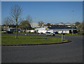
4
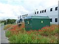
Bluestone Centre under construction
Part of the growing Solstice Park by the A303.
Image: © Hugh Venables
Taken: 8 Apr 2017
0.19 miles
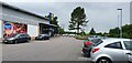
5
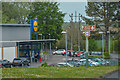
Amesbury : Lidl
Looking towards the Lidl store.
Image: © Lewis Clarke
Taken: 27 Apr 2019
0.21 miles
8
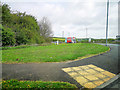
Amesbury : Roundabout
A roundabout with the view towards Porton Road.
Image: © Lewis Clarke
Taken: 27 Apr 2019
0.23 miles
9
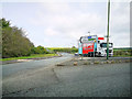
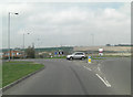
Amesbury : Porton Road
Looking off the roundabout and along Porton Road.
Image: © Lewis Clarke
Taken: 27 Apr 2019
0.24 miles
10
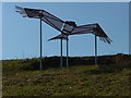
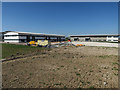
Amesbury - The Hawk
A new installation on Solstice Park.
Image: © Chris Talbot
Taken: 28 Sep 2011
0.25 miles