IMAGES TAKEN NEAR TO
Jaggard View, SALISBURY, SP4 7SS
Introduction
This page details the photographs taken nearby to Jaggard View, SP4 7SS by members of the Geograph project.
The Geograph project started in 2005 with the aim of publishing, organising and preserving representative images for every square kilometre of Great Britain, Ireland and the Isle of Man.

There are currently over 7.5m images from over14,400 individuals and you can help contribute to the project by visiting https://www.geograph.org.uk
Image Map (Loading...)


Getting Data...Please wait
Leaflet Map data © OpenStreetMap
Images are licensed for reuse under creativecommons.org/licenses/by-sa/2.0
Notes
- Clicking on the map will re-center to the selected point.
- The higher the marker number, the further away the image location is from the centre of the postcode.
Image Listing (4 Images Found)
Images are licensed for reuse under creativecommons.org/licenses/by-sa/2.0
Image
Details
Distance
1
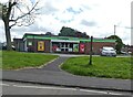
Co-op convenience shop on Beaulieu Road
Image: © Roger Cornfoot
Taken: 14 Jun 2024
0.10 miles
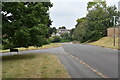
3
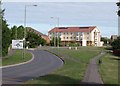
Roundabout, Amesbury
Porton Road approaches a roundabout where five roads meet. New flats have been built to the right of the largely hidden Image
Image: © Derek Harper
Taken: 2 Aug 2010
0.24 miles
4
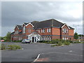
Amesbury Baptist Centre
Amesbury Baptist Centre is a purpose built community centre, paid for and run by the Amesbury Baptist Church which has its home there. It is situated on the Butterfield Down Estate, Amesbury, in the middle of a growing housing estate.
Image: © Jonathan Billinger
Taken: 4 Jul 2007
0.24 miles