IMAGES TAKEN NEAR TO
Coniston Close, SALISBURY, SP4 7QJ
Introduction
This page details the photographs taken nearby to Coniston Close, SP4 7QJ by members of the Geograph project.
The Geograph project started in 2005 with the aim of publishing, organising and preserving representative images for every square kilometre of Great Britain, Ireland and the Isle of Man.

There are currently over 7.5m images from over14,400 individuals and you can help contribute to the project by visiting https://www.geograph.org.uk
Image Map
Images are licensed for reuse under creativecommons.org/licenses/by-sa/2.0
Notes
- Clicking on the map will re-center to the selected point.
- The higher the marker number, the further away the image location is from the centre of the postcode.
Image Listing (14 Images Found)
Images are licensed for reuse under creativecommons.org/licenses/by-sa/2.0
Image
Details
Distance
1
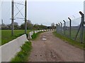
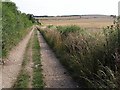
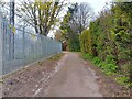
Amesbury Road byway
The byway beside Boscombe Down in Amesbury, known as Amesbury Road. Ahead the byway takes a bridge with a 7.5 ton weight limit.
Image: © Oscar Taylor
Taken: 22 Apr 2023
0.02 miles
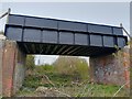
2
Railway bridge near Amesbury
A bridge across the line of the Amesbury and Military Camp Light Railway, carrying a byway, Amesbury Road, towards Bulford Camp.
Image: © Derek Harper
Taken: 2 Aug 2010
0.08 miles
3
Amesbury Road byway bridge
The bridge on the byway beside Boscombe Down in Amesbury, known as Amesbury Road. It doesn't appear to bridge over much nowadays. The bridge has a 7.5 ton weight limit.
Image: © Oscar Taylor
Taken: 22 Apr 2023
0.08 miles
4
Amesbury Road byway
The byway beside Boscombe Down in Amesbury, known as Amesbury Road.
Image: © Oscar Taylor
Taken: 22 Apr 2023
0.10 miles
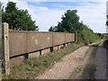
5
Amesbury Road
Image: © Derek Harper
Taken: 2 Aug 2010
0.10 miles
6
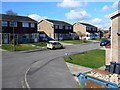
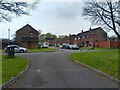
Nicolson Close, Amesbury
Shown here is typical 1970s speculative development in the north-east section of this south Wiltshire town.
Image: © Brian Robert Marshall
Taken: 12 Apr 2011
0.13 miles
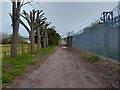
7
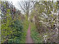
Boscombe Down footpath
A footpath to the north of Boscombe Down, between the byway known as Amesbury Road and Allington Track.
Image: © Oscar Taylor
Taken: 22 Apr 2023
0.13 miles
8
Amesbury Road byway
The byway beside Boscombe Down in Amesbury, known as Amesbury Road.
Image: © Oscar Taylor
Taken: 22 Apr 2023
0.14 miles
9
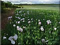
Poppies, Amesbury
These may be for morphine production. There are a lot of similar fields in this area around the Hampshire/Wiltshire border. This view is alongside Amesbury Road, the byway heading towards Bulford Camp. In the distance (at the end of the poppy field) you can see one of the Ratfyn Barrows. This is a group of three tumuli, though only one is immediately apparent (even close up). They are on a protected site between fields. A lot of other tumuli on the down have been lost to the plough.
Image: © Andrew Smith
Taken: 26 Jun 2007
0.18 miles
10
Cadnam Crescent over Milton Road, Amesbury
Looking from the byway known as Amesbury Road at Cadnam Crescent, over Milton Road. To the left (off camera) is Boscombe Down.
Image: © Oscar Taylor
Taken: 22 Apr 2023
0.18 miles