IMAGES TAKEN NEAR TO
Countess Road, SALISBURY, SP4 7AP
Introduction
This page details the photographs taken nearby to Countess Road, SP4 7AP by members of the Geograph project.
The Geograph project started in 2005 with the aim of publishing, organising and preserving representative images for every square kilometre of Great Britain, Ireland and the Isle of Man.

There are currently over 7.5m images from over14,400 individuals and you can help contribute to the project by visiting https://www.geograph.org.uk
Image Map
Images are licensed for reuse under creativecommons.org/licenses/by-sa/2.0
Notes
- Clicking on the map will re-center to the selected point.
- The higher the marker number, the further away the image location is from the centre of the postcode.
Image Listing (44 Images Found)
Images are licensed for reuse under creativecommons.org/licenses/by-sa/2.0
Image
Details
Distance
1
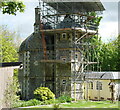
Diana's House, Amesbury
Diana's House under repair in 2021
Grade II* listed East gatehouse to Amesbury Abbey, 1600
https://historicengland.org.uk/listing/the-list/list-entry/1131053
Image: © Steve Roberts
Taken: 19 May 2021
0.10 miles
2
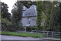
Diana's House
Grade II listed. http://www.britishlistedbuildings.co.uk/en-321341-diana-s-house-amesbury-
Image: © N Chadwick
Taken: 18 Sep 2015
0.10 miles
3
Diana's House
Diana is supposed to have been a mistress of Edward Seymour and there is an inscription over the door dating it as her house in 1600. It is described as a gatehouse to Amesbury Abbey but the original abbey was demolished in 1538 and the house that is currently known as Amesbury Abbey was not built until 1840 so it must have been an intervening house. Seymour was given the estate by the crown after the dissolution.
Image: © Nigel Mykura
Taken: 23 Jun 2013
0.10 miles
5
Site of Amesbury station, 1992
View eastward beside the (old) A303, towards Newton Tony and the triangular junctions with the ex-LSW London - Salisbury etc. main line near Porton: ex-LSW branch to Bulford and Bulford Camp; all closed to passengers 30/6/52, goods 4/3/63.
Image: © Ben Brooksbank
Taken: 14 Aug 1992
0.12 miles
7
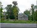
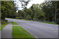
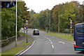
Amesbury : Countess Road A345
Countess Road heads off from the A303.
Image: © Lewis Clarke
Taken: 29 Mar 2018
0.13 miles
9
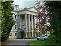
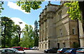
Amesbury Abbey, South facade, through trees
Image: © Steve Roberts
Taken: 19 May 2021
0.14 miles