IMAGES TAKEN NEAR TO
West Tisbury, SALISBURY, SP3 6SH
Introduction
This page details the photographs taken nearby to SP3 6SH by members of the Geograph project.
The Geograph project started in 2005 with the aim of publishing, organising and preserving representative images for every square kilometre of Great Britain, Ireland and the Isle of Man.

There are currently over 7.5m images from over14,400 individuals and you can help contribute to the project by visiting https://www.geograph.org.uk
Image Map
Images are licensed for reuse under creativecommons.org/licenses/by-sa/2.0
Notes
- Clicking on the map will re-center to the selected point.
- The higher the marker number, the further away the image location is from the centre of the postcode.
Image Listing (6 Images Found)
Images are licensed for reuse under creativecommons.org/licenses/by-sa/2.0
Image
Details
Distance
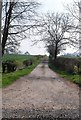
1
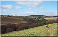
Footpath near Hatch
The footpath gradually moves away from the Oddford Brook as it makes its way towards Tuckingmill and Hatch.
Image: © Maigheach-gheal
Taken: 12 May 2011
0.17 miles
2
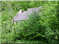
Abandoned mill near Lawn Farm
The old mill building stands beside the Oddford Brook.
Image: © Maigheach-gheal
Taken: 12 May 2011
0.18 miles
3
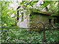
Abandoned mill near Lawn Farm
The abandoned stone mill stands beside the Oddford Brook.
Image: © Maigheach-gheal
Taken: 12 May 2011
0.18 miles
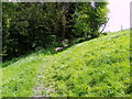
5
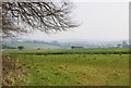
Looking Towards Oddford Brook
The brook is in the trees.
Image: © Maigheach-gheal
Taken: 20 Feb 2005
0.22 miles