IMAGES TAKEN NEAR TO
Hindon Lane, SALISBURY, SP3 6QG
Introduction
This page details the photographs taken nearby to Hindon Lane, SP3 6QG by members of the Geograph project.
The Geograph project started in 2005 with the aim of publishing, organising and preserving representative images for every square kilometre of Great Britain, Ireland and the Isle of Man.

There are currently over 7.5m images from over14,400 individuals and you can help contribute to the project by visiting https://www.geograph.org.uk
Image Map (Loading...)


Getting Data...Please wait
Leaflet Map data © OpenStreetMap
Images are licensed for reuse under creativecommons.org/licenses/by-sa/2.0
Notes
- Clicking on the map will re-center to the selected point.
- The higher the marker number, the further away the image location is from the centre of the postcode.
Image Listing (27 Images Found)
Images are licensed for reuse under creativecommons.org/licenses/by-sa/2.0
Image
Details
Distance
1
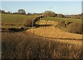
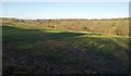
Field north of Tisbury
The footpath from Tisbury, following a telegraph line up the west side of the Fonthill Brook valley crosses a re-entrant with an unharvested field glowing in the winter sun.
Image: © Derek Harper
Taken: 9 Jan 2011
0.07 miles
2
View from Hindon Lane
Looking north from Hindon Lane near Tisbury.
Image: © Wayland Smith
Taken: 4 Dec 2021
0.09 miles
3
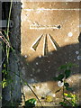
Bench Mark, The Gables
The bench mark is to be found on the north angle of the north west face of the building. For a wider view of the building Image and for further information on the cut mark http://www.bench-marks.org.uk/bm35977
A bench mark is an Ordnance Survey arrowhead sign found on walls, bridges, churches and specially erected triangulation pillars where the altitude above sea-level has been accurately measured by surveyors. The arrowhead points to a horizontal line above it which marks the exact altitude.
With rivets and pivots there is no datum (horizontal line) cut, the pointed-to horizontal surface defining the datum height.
Image: © Maigheach-gheal
Taken: 10 Nov 2010
0.09 miles
4
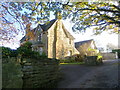
The Gables, Tisbury
The Gables is a detached house on Hindon Lane. There is an Ordnance Survey bench mark on the north west face of the building.
Image: © Maigheach-gheal
Taken: 10 Nov 2010
0.10 miles
5
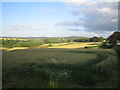
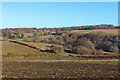
Fields near Hindon Lane, Tisbury
These wheat fields are on the side of a gentle valley south of Ashley Wood Farm. The wood to the left is Hillground Copse, and Hindon Lane is on the right. The un-named stream in the valley, which is not visible, comes from Fonthill Lake, and flows south-east to join the River Nadder about 2km away.
Image: © Andy Gryce
Taken: 6 Jul 2007
0.11 miles
6
Field north of Tisbury
A reverse view of Image, with the Fonthill Brook valley on the left. Frost can be seen up the hill on the right beneath the hedge.
Image: © Derek Harper
Taken: 9 Jan 2011
0.12 miles
8
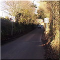
From 30 to 40 along Hindon Lane, Tisbury
Faced with an increase in the speed limit along this narrow lane without pavements,
this walker turned around and headed back towards the centre of the village.
Image: © Jaggery
Taken: 13 Dec 2014
0.15 miles
9
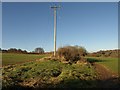
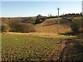
Telegraph pole above Fonthill valley
One of the line followed by the footpath mentioned in Image; but here, the path veers off to the right across the field of winter wheat, and towards Fonthill Lake.
Image: © Derek Harper
Taken: 9 Jan 2011
0.15 miles
10
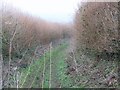
Field near Tisbury
A footpath sets out towards the left across the shadows lengthening over this field of grass on the slopes of the Fonthill Brook valley.
Image: © Derek Harper
Taken: 9 Jan 2011
0.16 miles