IMAGES TAKEN NEAR TO
Tisbury, SALISBURY, SP3 6PQ
Introduction
This page details the photographs taken nearby to SP3 6PQ by members of the Geograph project.
The Geograph project started in 2005 with the aim of publishing, organising and preserving representative images for every square kilometre of Great Britain, Ireland and the Isle of Man.

There are currently over 7.5m images from over14,400 individuals and you can help contribute to the project by visiting https://www.geograph.org.uk
Image Map (Loading...)


Getting Data...Please wait
Leaflet Map data © OpenStreetMap
Images are licensed for reuse under creativecommons.org/licenses/by-sa/2.0
Notes
- Clicking on the map will re-center to the selected point.
- The higher the marker number, the further away the image location is from the centre of the postcode.
Image Listing (8 Images Found)
Images are licensed for reuse under creativecommons.org/licenses/by-sa/2.0
Image
Details
Distance
2
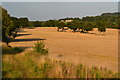
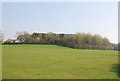
Field beside railway near Savage Bridge
Image: © David Martin
Taken: 11 Aug 2020
0.12 miles
3
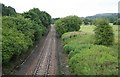
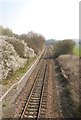
Waterloo - Exeter Railway looking towards Tisbury
Now a single line once double track. The trees could do with a trim.
Image: © roger geach
Taken: 2 Jul 2010
0.15 miles
4

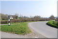
Approaching Savage Bridge
You can see the walls of the bridge which crosses the River Sem.
Image: © Toby
Taken: 7 Apr 2007
0.16 miles
5
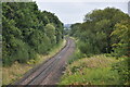
Railway west of Tisbury
A view east of the ex London & South Western Railway (LSWR) main Salisbury to Exeter railway line. This has suffered downgrading in past years, being singled for much of its length, but hopefully it might be upgraded in the future, with rail traffic increasing.
Image: © Bob Walters
Taken: 5 Sep 2017
0.17 miles
8
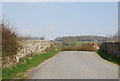
Over the railway
This bridge crosses the railway heading west from Tisbury.
Image: © Toby
Taken: 7 Apr 2007
0.22 miles