IMAGES TAKEN NEAR TO
Tisbury, SALISBURY, SP3 6NU
Introduction
This page details the photographs taken nearby to SP3 6NU by members of the Geograph project.
The Geograph project started in 2005 with the aim of publishing, organising and preserving representative images for every square kilometre of Great Britain, Ireland and the Isle of Man.

There are currently over 7.5m images from over14,400 individuals and you can help contribute to the project by visiting https://www.geograph.org.uk
Image Map (Loading...)


Getting Data...Please wait
Leaflet Map data © OpenStreetMap
Images are licensed for reuse under creativecommons.org/licenses/by-sa/2.0
Notes
- Clicking on the map will re-center to the selected point.
- The higher the marker number, the further away the image location is from the centre of the postcode.
Image Listing (3 Images Found)
Images are licensed for reuse under creativecommons.org/licenses/by-sa/2.0
Image
Details
Distance
1
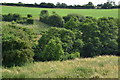
Across the valley of the Oddford Brook
The path back to Tisbury here invisibly descended a steep, uneven field of shoulder-high nettles and was deemed impassable: maybe try another time of year?
Image: © David Martin
Taken: 23 Jun 2018
0.18 miles
2
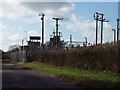
Electricity Sub Station, Tuckingmill
Image: © Maigheach-gheal
Taken: 9 Mar 2007
0.21 miles
3
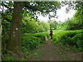
Footpath near Tuckingmill
The footpath takes walkers towards Tuckingmill from Lawn.
Image: © Maigheach-gheal
Taken: 12 May 2011
0.25 miles