IMAGES TAKEN NEAR TO
Chicksgrove, Tisbury, SALISBURY, SP3 6LY
Introduction
This page details the photographs taken nearby to SP3 6LY by members of the Geograph project.
The Geograph project started in 2005 with the aim of publishing, organising and preserving representative images for every square kilometre of Great Britain, Ireland and the Isle of Man.

There are currently over 7.5m images from over14,400 individuals and you can help contribute to the project by visiting https://www.geograph.org.uk
Image Map (Loading...)


Getting Data...Please wait
Leaflet Map data © OpenStreetMap
Images are licensed for reuse under creativecommons.org/licenses/by-sa/2.0
Notes
- Clicking on the map will re-center to the selected point.
- The higher the marker number, the further away the image location is from the centre of the postcode.
Image Listing (6 Images Found)
Images are licensed for reuse under creativecommons.org/licenses/by-sa/2.0
Image
Details
Distance
1
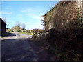
Staddle Stones at Quarry Farm, Upper Chicksgrove
Image: © Maigheach-gheal
Taken: 14 Feb 2007
0.03 miles
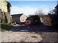
3
Bridleway to Chilmark from Upper Chicksgrove
Image: © Maigheach-gheal
Taken: 14 Feb 2007
0.10 miles
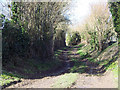
4
Along the lane
Looking along the road in the direction of Upper Chicksgrove from close to the Image Quite narrow, this is a busy road with traffic travelling fast.
Image: © Jonathan Kington
Taken: 13 Oct 2011
0.17 miles
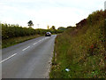
5
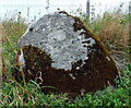
Roadside boulder
Located on the roadside roughly halfway between Upper and Lower Chicksgrove, this boulder has a benchmark on it. For a wider view see Image and for further information visit http://www.bench-marks.org.uk/bm39786 .
Image: © Jonathan Kington
Taken: 13 Oct 2011
0.22 miles
6
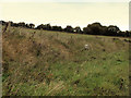
Up into the field
Looking from the road between Upper and Lower Chicksgrove, over the Image and into the field behind. There is an Ordnance Survey benchmark on the nearest face of the boulder.
Image: © Jonathan Kington
Taken: 13 Oct 2011
0.25 miles