IMAGES TAKEN NEAR TO
Tisbury, SALISBURY, SP3 6JS
Introduction
This page details the photographs taken nearby to SP3 6JS by members of the Geograph project.
The Geograph project started in 2005 with the aim of publishing, organising and preserving representative images for every square kilometre of Great Britain, Ireland and the Isle of Man.

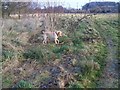
There are currently over 7.5m images from over14,400 individuals and you can help contribute to the project by visiting https://www.geograph.org.uk
Image Map
Images are licensed for reuse under creativecommons.org/licenses/by-sa/2.0
Notes
- Clicking on the map will re-center to the selected point.
- The higher the marker number, the further away the image location is from the centre of the postcode.
Image Listing (151 Images Found)
Images are licensed for reuse under creativecommons.org/licenses/by-sa/2.0
Image
Details
Distance
1
Approaching Tisbury by train from the east
Image: © Rob Purvis
Taken: 5 Oct 2011
0.08 miles
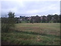
2
Looking towards Tisbury
Taken from the footpath that runs beside the railway line.
Image: © Maigheach-gheal
Taken: 17 Dec 2007
0.08 miles
3
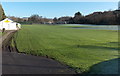
Pavilion and football pitch, Tisbury
Located near Tisbury railway station on level ground on a bank of the River Nadder.
The name on the pavilion is Tisbury Sports & Social Club.
Image: © Jaggery
Taken: 13 Dec 2014
0.08 miles
4
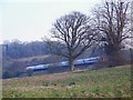
Waiting on the Loop
The up train waits on the loop for the Exeter bound train to pass just outside of Tisbury Station.
Image: © Maigheach-gheal
Taken: 17 Dec 2007
0.09 miles
5
Permissive path beside the River Nadder
A permissive path used by local dog walkers between the River Nadder and the railway line.
Image: © Maigheach-gheal
Taken: 17 Dec 2007
0.09 miles
6
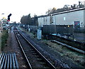
Railway from Tisbury towards Salisbury
Looking NE from Tisbury railway station. Although Tisbury is on the London Waterloo to Exeter main line, this section through the station is single track. The train journey to Salisbury (ahead) takes about 15 minutes. Gillingham (Dorset) is about 10 minutes away in the opposite direction.
Image: © Jaggery
Taken: 13 Dec 2014
0.09 miles
7

Bridge over the River Nadder
The bridge carries the road over the River Nadder. The river is exceptionally low after a very dry April.
Image: © Maigheach-gheal
Taken: 6 May 2011
0.12 miles
8
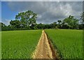
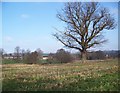
Path east of Tisbury
It's nice when landowners make the effort to show the way across their land.
Image: © Neil Theasby
Taken: 12 Jun 2022
0.13 miles
9
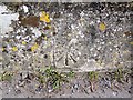
Bench Mark, Tisbury
The mark is to be found on the road bridge over the River Nadder. http://www.bench-marks.org.uk/bm33393
Image: © Maigheach-gheal
Taken: 10 Mar 2010
0.13 miles
10
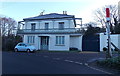
Bridge House, Tisbury
Distinctive house located between a road bridge over the River Nadder and the approach road to Tisbury railway station. The edge of the red and white Tisbury station name sign http://www.geograph.org.uk/photo/4277265 is on the right.
Image: © Jaggery
Taken: 13 Dec 2014
0.13 miles