IMAGES TAKEN NEAR TO
East Knoyle, SALISBURY, SP3 6DE
Introduction
This page details the photographs taken nearby to SP3 6DE by members of the Geograph project.
The Geograph project started in 2005 with the aim of publishing, organising and preserving representative images for every square kilometre of Great Britain, Ireland and the Isle of Man.

There are currently over 7.5m images from over14,400 individuals and you can help contribute to the project by visiting https://www.geograph.org.uk
Image Map
Images are licensed for reuse under creativecommons.org/licenses/by-sa/2.0
Notes
- Clicking on the map will re-center to the selected point.
- The higher the marker number, the further away the image location is from the centre of the postcode.
Image Listing (5 Images Found)
Images are licensed for reuse under creativecommons.org/licenses/by-sa/2.0
Image
Details
Distance
1
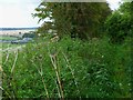
The Orange Way in Wiltshire (54)
The bridleway is wet and overgrown. Over to the left is Holden Farm.
Image: © Shazz
Taken: 26 Sep 2012
0.10 miles
2
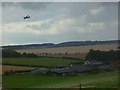
The Orange Way in Wiltshire (55)
Here is a closer view of Holden Farm with a Hurricane heading to the Royal Naval Air Station Yeovilton.
Image: © Shazz
Taken: 26 Sep 2012
0.12 miles
3
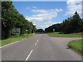
Two Mile Down
A view looking to the southeast along the B3089 towards the traffic-light controlled junction with the A350.
Image: © Phil Williams
Taken: 9 Jul 2006
0.19 miles
4

The A350 at Two Mile Down
A view looking down the A350 as it passes under the A303 at Two Mile Down.
Image: © Phil Williams
Taken: 9 Jul 2006
0.19 miles
5
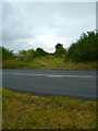
The Orange Way in Wiltshire (56)
Crossing the A350 provides a short relief from the wet and slug-ridden bridleway.
Image: © Shazz
Taken: 26 Sep 2012
0.22 miles