IMAGES TAKEN NEAR TO
Shaftesbury Road, SALISBURY, SP3 6AT
Introduction
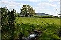
This page details the photographs taken nearby to Shaftesbury Road, SP3 6AT by members of the Geograph project.
The Geograph project started in 2005 with the aim of publishing, organising and preserving representative images for every square kilometre of Great Britain, Ireland and the Isle of Man.

There are currently over 7.5m images from over14,400 individuals and you can help contribute to the project by visiting https://www.geograph.org.uk
Image Map
Images are licensed for reuse under creativecommons.org/licenses/by-sa/2.0
Notes
- Clicking on the map will re-center to the selected point.
- The higher the marker number, the further away the image location is from the centre of the postcode.
Image Listing (2 Images Found)
Images are licensed for reuse under creativecommons.org/licenses/by-sa/2.0
Image
Details
Distance
1
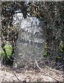
Old Milestone by the A350, Shaftesbury Road, East Knoyle parish
Carved stone post by the A350, in parish of East Knoyle (Salisbury District), Shaftesbury Road, The Turnpike, by Southernmost unnamed cottage in hedgerow on bend, on East side of road. Shaston stone, erected by the Shaftesbury & New Road to Blandford turnpike trust in the 19th century.
Inscription reads:-
: EAST KNOYLE (vertical) : : IV / Miles from / SHASTON : : (not possible to see) :
Carved benchmark lower front middle.
Grade II listed.
List Entry Number: 1131144 https://historicengland.org.uk/listing/the-list/list-entry/1131144
Milestone Society National ID: WI_WMSH11
Image: © M Faherty
Taken: 13 Mar 2007
0.05 miles