IMAGES TAKEN NEAR TO
Hillside, SALISBURY, SP3 5SL
Introduction
This page details the photographs taken nearby to Hillside, SP3 5SL by members of the Geograph project.
The Geograph project started in 2005 with the aim of publishing, organising and preserving representative images for every square kilometre of Great Britain, Ireland and the Isle of Man.

There are currently over 7.5m images from over14,400 individuals and you can help contribute to the project by visiting https://www.geograph.org.uk
Image Map
Images are licensed for reuse under creativecommons.org/licenses/by-sa/2.0
Notes
- Clicking on the map will re-center to the selected point.
- The higher the marker number, the further away the image location is from the centre of the postcode.
Image Listing (5 Images Found)
Images are licensed for reuse under creativecommons.org/licenses/by-sa/2.0
Image
Details
Distance
3
Old Milestone by the B3089, Hindon Road, Fonthill Bishop
Carved stone post by the B3089, in parish of Fonthill Bishop (Salisbury District), Hindon Road; opposite terrace of brick cottages, East of village, on the verge, on South side of road. Hindon stone, erected by the Fisherton, Wilton, Heytesbury, Willoughby Hedge & Redhone turnpike trust in the 19th century.
Inscription reads:-
(SA)RUM
XIV
HIND(ON)
(II)
Milestone Society National ID: WI_SAMR14
Image: © M Faherty
Taken: 17 Feb 2007
0.07 miles
4
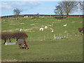
A pony and alpaca at Fonthill Bishop
Image: © Maigheach-gheal
Taken: 9 Mar 2007
0.23 miles
5
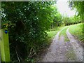
The Orange Way in Wiltshire (71)
The Orange Way reaches Fonthill Clump.
Image: © Shazz
Taken: 28 Sep 2012
0.25 miles