IMAGES TAKEN NEAR TO
Ansty, SALISBURY, SP3 5PS
Introduction
This page details the photographs taken nearby to SP3 5PS by members of the Geograph project.
The Geograph project started in 2005 with the aim of publishing, organising and preserving representative images for every square kilometre of Great Britain, Ireland and the Isle of Man.

There are currently over 7.5m images from over14,400 individuals and you can help contribute to the project by visiting https://www.geograph.org.uk
Image Map (Loading...)


Getting Data...Please wait
Leaflet Map data © OpenStreetMap
Images are licensed for reuse under creativecommons.org/licenses/by-sa/2.0
Notes
- Clicking on the map will re-center to the selected point.
- The higher the marker number, the further away the image location is from the centre of the postcode.
Image Listing (6 Images Found)
Images are licensed for reuse under creativecommons.org/licenses/by-sa/2.0
Image
Details
Distance
1
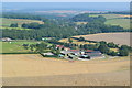
View over South Farm with Ansty in the distance
Image: © David Martin
Taken: 11 Aug 2020
0.04 miles

5
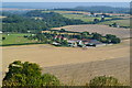
Wiltshire Downland
Anstey Coombe from Middle Down.
Image: © Colin Smith
Taken: 18 Aug 2015
0.24 miles
6
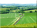
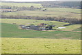
Ansty: a fine view from the ridge
A northward view from the ridge south of the village of Ansty, which lies hidden down the valley in the centre of the picture. The prominent road comes steeply up to where we are standing, by way of a couple of zigzag bends.
Image: © Chris Downer
Taken: 8 Jun 2013
0.25 miles