IMAGES TAKEN NEAR TO
Swallowcliffe, SALISBURY, SP3 5PE
Introduction
This page details the photographs taken nearby to SP3 5PE by members of the Geograph project.
The Geograph project started in 2005 with the aim of publishing, organising and preserving representative images for every square kilometre of Great Britain, Ireland and the Isle of Man.

There are currently over 7.5m images from over14,400 individuals and you can help contribute to the project by visiting https://www.geograph.org.uk
Image Map (Loading...)


Getting Data...Please wait
Leaflet Map data © OpenStreetMap
Images are licensed for reuse under creativecommons.org/licenses/by-sa/2.0
Notes
- Clicking on the map will re-center to the selected point.
- The higher the marker number, the further away the image location is from the centre of the postcode.
Image Listing (3 Images Found)
Images are licensed for reuse under creativecommons.org/licenses/by-sa/2.0
Image
Details
Distance
1
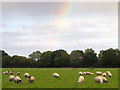
Grazing sheep near Swallowcliffe
The sheep graze under the remains of a rainbow.
Image: © Maigheach-gheal
Taken: 19 Oct 2011
0.11 miles
2
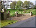
Entrance, Swallowcliffe Manor
The pillars mark the entrance to the Manor House.
Image: © Maigheach-gheal
Taken: 25 Apr 2010
0.14 miles
3
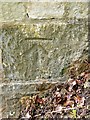
Bench Mark, Swallowcliffe Manor
The bench mark is on one of the gate pillars. For a view of the entrance Image The bench mark is on the right hand pillar. http://www.bench-marks.org.uk/bm34145
A bench mark is an Ordnance Survey arrowhead sign found on walls, bridges, churches and specially erected triangulation pillars where the altitude above sea-level has been accurately measured by surveyors. The arrowhead points to a horizontal line above it which marks the exact altitude.
With rivets and pivots there is no datum (horizontal line) cut, the pointed-to horizontal surface defining the datum height.
Image: © Maigheach-gheal
Taken: 25 Apr 2010
0.15 miles