IMAGES TAKEN NEAR TO
Sutton Mandeville, SALISBURY, SP3 5LX
Introduction
This page details the photographs taken nearby to SP3 5LX by members of the Geograph project.
The Geograph project started in 2005 with the aim of publishing, organising and preserving representative images for every square kilometre of Great Britain, Ireland and the Isle of Man.

There are currently over 7.5m images from over14,400 individuals and you can help contribute to the project by visiting https://www.geograph.org.uk
Image Map (Loading...)


Getting Data...Please wait
Leaflet Map data © OpenStreetMap
Images are licensed for reuse under creativecommons.org/licenses/by-sa/2.0
Notes
- Clicking on the map will re-center to the selected point.
- The higher the marker number, the further away the image location is from the centre of the postcode.
Image Listing (17 Images Found)
Images are licensed for reuse under creativecommons.org/licenses/by-sa/2.0
Image
Details
Distance
1
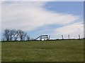
Stile on the skyline, Sutton Mandeville
The path pushes on up the hill towards the corner of Great Ground Hill.
Image: © Maigheach-gheal
Taken: 25 Mar 2008
0.04 miles
3
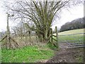
Stile and footpath towards Great Ground Hill
The stile is beside the cottage called Wyndhams and one path heads uphill towards Great Ground Hill and the other goes right towards Sutton Mandeville.
Image: © Maigheach-gheal
Taken: 25 Mar 2008
0.05 miles
4
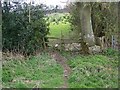
Stile near Sutton Mandeville
The stile is on the corner of the woodland on Great Ground Hill.
Image: © Maigheach-gheal
Taken: 25 Mar 2008
0.05 miles
5
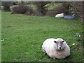
Resting sheep near Sutton Mandeville
These two were resting beside the footpath.
Image: © Maigheach-gheal
Taken: 25 Mar 2008
0.06 miles
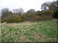
7
Ancient Hedge, Great Ground Hill
It is difficult to date hedges unless there is documentary evidence as to their planting, but one theory is to count the species in a 30 metre stretch and each species counts as a century. Only count older plants and not saplings.
Image: © Maigheach-gheal
Taken: 25 Mar 2008
0.09 miles
8
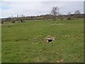
Water meadows near Sutton Mandeville
The fields formed part of the now abandoned water meadows system.
Image: © Maigheach-gheal
Taken: 25 Mar 2008
0.11 miles
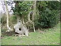
9
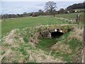
Bridge near Sutton Mandeville
Part of the workings, that formed the long abandoned water meadows system.
Image: © Maigheach-gheal
Taken: 25 Mar 2008
0.16 miles
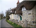
10
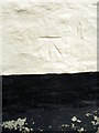
Bench Mark, Daslett Cottage
The bench mark is to be found on the south east angle of the cottage. For a view of the building Image and for further information on the cut mark and others in the area http://www.bench-marks.org.uk/bm37374
Image: © Maigheach-gheal
Taken: 20 Mar 2011
0.17 miles