IMAGES TAKEN NEAR TO
Fovant, SALISBURY, SP3 5LQ
Introduction
This page details the photographs taken nearby to SP3 5LQ by members of the Geograph project.
The Geograph project started in 2005 with the aim of publishing, organising and preserving representative images for every square kilometre of Great Britain, Ireland and the Isle of Man.

There are currently over 7.5m images from over14,400 individuals and you can help contribute to the project by visiting https://www.geograph.org.uk
Image Map (Loading...)


Getting Data...Please wait
Leaflet Map data © OpenStreetMap
Images are licensed for reuse under creativecommons.org/licenses/by-sa/2.0
Notes
- Clicking on the map will re-center to the selected point.
- The higher the marker number, the further away the image location is from the centre of the postcode.
Image Listing (8 Images Found)
Images are licensed for reuse under creativecommons.org/licenses/by-sa/2.0
Image
Details
Distance
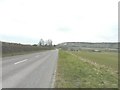
2
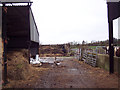
A30 heading west from Fovant
New Barn Cottages on the left.
Image: © Robin Webster
Taken: 10 Jun 2018
0.05 miles
3
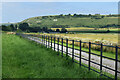
Roadside fence with view of Fovant Badges
Image: © David Martin
Taken: 15 Jul 2021
0.12 miles
4

Sunset, Fovant
The sunsets over New Barn.
Image: © Maigheach-gheal
Taken: 15 Feb 2012
0.18 miles
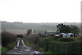
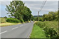
6
Distant view of The Badges, Fovant from the A30
The next right turn is signposted Broad Chalke and is just before one reaches West Farm in Image
Image: © John Baker
Taken: 30 Mar 2013
0.21 miles
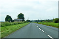
7
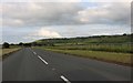
The A30 looking towards the Fovant Badges
These are regimental badges carved into the chalk of Fovant Down https://en.wikipedia.org/wiki/Fovant_Badges
Image: © David Howard
Taken: 20 Jun 2020
0.21 miles
8
A30 south of Sutton Mandeville
Entry to the footpath south from this point was unpassable, being completely blocked by head-high nettles, thistles and brambles.
Image: © David Martin
Taken: 15 Jul 2021
0.22 miles