IMAGES TAKEN NEAR TO
Middle Ground, SALISBURY, SP3 5LP
Introduction
This page details the photographs taken nearby to Middle Ground, SP3 5LP by members of the Geograph project.
The Geograph project started in 2005 with the aim of publishing, organising and preserving representative images for every square kilometre of Great Britain, Ireland and the Isle of Man.

There are currently over 7.5m images from over14,400 individuals and you can help contribute to the project by visiting https://www.geograph.org.uk
Image Map (Loading...)


Getting Data...Please wait
Leaflet Map data © OpenStreetMap
Images are licensed for reuse under creativecommons.org/licenses/by-sa/2.0
Notes
- Clicking on the map will re-center to the selected point.
- The higher the marker number, the further away the image location is from the centre of the postcode.
Image Listing (16 Images Found)
Images are licensed for reuse under creativecommons.org/licenses/by-sa/2.0
Image
Details
Distance
1
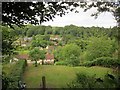
Fovant
From footpath FOVA 7, looking across the valley of the stream along which the village lies.
Image: © Derek Harper
Taken: 27 Jun 2015
0.06 miles
3
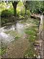
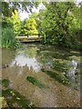
Fovant Stream
An attractive spot on the stream that flows through the village, at the junction by Image
Image: © Derek Harper
Taken: 27 Jun 2015
0.08 miles
4
Fovant Stream
The same pool as Image], looking upstream to where a little bridge gives access to a single property.
Image: © Derek Harper
Taken: 27 Jun 2015
0.08 miles
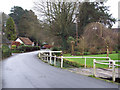
6
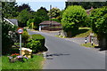
Dinton Road, at the top of Mill Lane
Mill Lane descends sharply to the right, leading to the former mill.
Image: © David Martin
Taken: 23 Jun 2018
0.11 miles
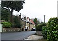
7
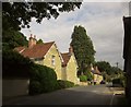
High Street, Fovant
Houses along the north-east side of the village street. The former post office and adjoining cottage http://list.historicengland.org.uk/resultsingle.aspx?uid=1146129&searchtype=mapsearch , further along, are shown in Image
Image: © Derek Harper
Taken: 27 Jun 2015
0.12 miles
8
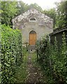
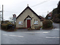
Fovant Free Church
Surprisingly for the first-time visitor, the notice on the gate to this Congregational chapel states "ABSOLUTELY NO FISHING". Immediately beyond the gate, the path crosses a tiny bridge over the Fovant Stream to reach the charming little chapel, which dates from about 1800 http://list.historicengland.org.uk/resultsingle.aspx?uid=1146131&searchtype=mapsearch . A hard subject to photograph with the sun in and the brightly-lit sky behind; the accessible churchyard is all on the southern side and very confined. Perhaps early morning would be the best time.
Image: © Derek Harper
Taken: 27 Jun 2015
0.13 miles
9
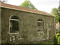
Fovant Free Church
As explained at Image this Congregational chapel is very hard to photograph; this view is from the confined churchyard on the south side of the building. http://www.historicengland.org.uk/listing/the-list/list-entry/1146131
Image: © Derek Harper
Taken: 27 Jun 2015
0.13 miles