IMAGES TAKEN NEAR TO
Dinton, SALISBURY, SP3 5EZ
Introduction
This page details the photographs taken nearby to SP3 5EZ by members of the Geograph project.
The Geograph project started in 2005 with the aim of publishing, organising and preserving representative images for every square kilometre of Great Britain, Ireland and the Isle of Man.

There are currently over 7.5m images from over14,400 individuals and you can help contribute to the project by visiting https://www.geograph.org.uk
Image Map (Loading...)


Getting Data...Please wait
Leaflet Map data © OpenStreetMap
Images are licensed for reuse under creativecommons.org/licenses/by-sa/2.0
Notes
- Clicking on the map will re-center to the selected point.
- The higher the marker number, the further away the image location is from the centre of the postcode.
Image Listing (18 Images Found)
Images are licensed for reuse under creativecommons.org/licenses/by-sa/2.0
Image
Details
Distance
1
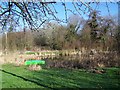
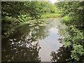
Duck Pond
This pond is beside the River Nadder and is the home of many ornamental ducks.
Image: © Maigheach-gheal
Taken: 11 Feb 2008
0.02 miles
2
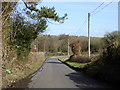
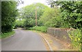
Catherine Ford Lane
Descending to cross the River Nadder, by bridge, these days.
Image: © Robin Webster
Taken: 2 Mar 2017
0.03 miles
3
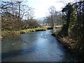
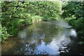
River Nadder near Dinton
Looking downstream.
Image: © Maigheach-gheal
Taken: 11 Feb 2008
0.06 miles
4
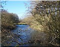
River Nadder near Dinton
Looking upstream.
Image: © Maigheach-gheal
Taken: 11 Feb 2008
0.06 miles
5
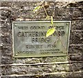
Plaque, Catherine Ford Bridge
Commemorating the rebuilding of the bridge in 1938, and crediting it to Howard Sims Ganderton (1890-1954), Wiltshire's County Surveyor at the time. As explained in Image], it seems odd that this plaque is on the bridge over the minor channel rather than the bridge over the Nadder itself.
Image: © Derek Harper
Taken: 27 Jun 2015
0.07 miles
6
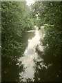
River Nadder
Looking upstream from Catherine Ford Bridge, into the light, so a murky scene.Image] looks downstream.
Image: © Derek Harper
Taken: 27 Jun 2015
0.07 miles
7
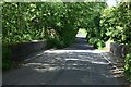
Catherine Ford Bridge
Actually two bridges (over the River Nadder), the nearer across a side channel, and ironically the one that carries a plaque commemorating the rebuilding of the bridge(s) in 1938.
Image: © Derek Harper
Taken: 27 Jun 2015
0.07 miles
9
River Nadder
Looking downstream from Catherine Ford Bridge, from the further of the parapets shown in Image Image] looks upstream.
Image: © Derek Harper
Taken: 27 Jun 2015
0.10 miles
10
River Nadder from Catherine Ford Bridge
Image: © David Martin
Taken: 4 Jun 2022
0.10 miles