IMAGES TAKEN NEAR TO
Shaftesbury Road, SALISBURY, SP3 5DH
Introduction
This page details the photographs taken nearby to Shaftesbury Road, SP3 5DH by members of the Geograph project.
The Geograph project started in 2005 with the aim of publishing, organising and preserving representative images for every square kilometre of Great Britain, Ireland and the Isle of Man.

There are currently over 7.5m images from over14,400 individuals and you can help contribute to the project by visiting https://www.geograph.org.uk
Image Map (Loading...)


Getting Data...Please wait
Leaflet Map data © OpenStreetMap
Images are licensed for reuse under creativecommons.org/licenses/by-sa/2.0
Notes
- Clicking on the map will re-center to the selected point.
- The higher the marker number, the further away the image location is from the centre of the postcode.
Image Listing (29 Images Found)
Images are licensed for reuse under creativecommons.org/licenses/by-sa/2.0
Image
Details
Distance
1

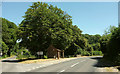
Bus shelter serving Compton Chamberlayne
The A30 passes south of the village, so this shelter links to the transport route along the main road.
Image: © David Smith
Taken: 22 Jun 2013
0.04 miles
2
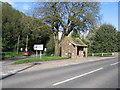
Bus shelter, Compton Chamberlayne
The A30 passes the turn into the village - lorries over 7.5 tonnes not wanted.
Image: © Derek Harper
Taken: 30 Jun 2018
0.06 miles
3
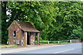
Brick bus shelter at Compton Chamberlayne
Image: © David Martin
Taken: 31 May 2019
0.06 miles
4
Compton Bus Stop
There used to be a handy little window in the side enabling you to see buses approaching from Shaftesbury, but it has been bricked up.
Image: © William Avery
Taken: 26 Oct 2006
0.07 miles
5
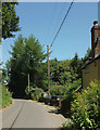
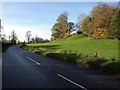
High Street, Compton Chamberlayne
Passing Cricket Field House on its way through the village.
Image: © Derek Harper
Taken: 30 Jun 2018
0.08 miles
6
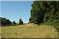
Field, Compton Chamberlayne
The field is also shown in Image This view is from a gateway on High Street.
Image: © Derek Harper
Taken: 30 Jun 2018
0.09 miles
8
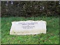
Sign for Compton Chamberlayne Burial Ground
This engraved stone indicates that behind the hedge is the village burial ground and a large area devoted to Commonwealth War Graves.
Image: © Maigheach-gheal
Taken: 25 Jan 2009
0.12 miles
9
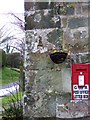
George V postbox, Compton Chamberlayne
In the cottage wall beside the telephone kiosk.
Image: © Maigheach-gheal
Taken: 25 Jan 2009
0.13 miles
10
Manor Farm, Compton Chamberlayne
Footpath CCHA4n goes through the farmyard.
Image: © Derek Harper
Taken: 30 Jun 2018
0.14 miles