IMAGES TAKEN NEAR TO
West Street, SALISBURY, SP3 4AJ
Introduction
This page details the photographs taken nearby to West Street, SP3 4AJ by members of the Geograph project.
The Geograph project started in 2005 with the aim of publishing, organising and preserving representative images for every square kilometre of Great Britain, Ireland and the Isle of Man.

There are currently over 7.5m images from over14,400 individuals and you can help contribute to the project by visiting https://www.geograph.org.uk
Image Map (Loading...)


Getting Data...Please wait
Leaflet Map data © OpenStreetMap
Images are licensed for reuse under creativecommons.org/licenses/by-sa/2.0
Notes
- Clicking on the map will re-center to the selected point.
- The higher the marker number, the further away the image location is from the centre of the postcode.
Image Listing (72 Images Found)
Images are licensed for reuse under creativecommons.org/licenses/by-sa/2.0
Image
Details
Distance
1
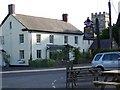
Village scene, Barford St Martin
The tower of St Martin's Church stands behind a large village house. The house which has an Ordnance Survey flush bracket on it sands opposite the Barford Inn.
Image: © Maigheach-gheal
Taken: 17 Jun 2010
0.01 miles
2
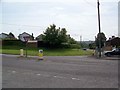
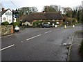
Road junction at Barford St Martin
The minor road joins the A30 on this very bad bend.
Image: © Maigheach-gheal
Taken: 30 Sep 2007
0.01 miles
3
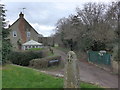
Barford St Martin: looking from the churchyard towards Church Lane Cottages
Image: © Basher Eyre
Taken: 28 Dec 2013
0.01 miles
4
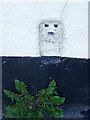
Flush Bracket S9602, Barford St Martin
For a wider view Image and for information on the flush bracket http://www.bench-marks.org.uk/bm19046
A bench mark is an Ordnance Survey arrowhead sign found on walls, bridges, churches and specially erected triangulation pillars where the altitude above sea-level has been accurately measured by surveyors. The arrowhead points to a horizontal line above it which marks the exact altitude.
With rivets and pivots there is no datum (horizontal line) cut, the pointed-to horizontal surface defining the datum height.
Image: © Maigheach-gheal
Taken: 17 Jun 2010
0.01 miles
5
![Barford St Martin houses [11]](https://s3.geograph.org.uk/geophotos/07/19/33/7193399_8100ca9f_120x120.jpg)
Barford St Martin houses [11]
Briden House, West Street, was formerly named Chelsea Cottage and was a house and restaurant. Built circa 1800 and constructed of painted brick under a Welsh slate roof. There are two parallel ranges and a central 19th century shopfront. Listed, grade II, with details at: https://historicengland.org.uk/listing/the-list/list-entry/1182954
Barford St Martin is a village in Wiltshire, some 2½ miles west of Wilton. The village is set on the north bank of the River Nadder at the junction of the B3089 road with the A30 road. There is evidence of occupation from the Iron Age onwards. Most working residents commute to Wilton or to Salisbury.
Image: © Michael Dibb
Taken: 20 Apr 2022
0.01 miles
7
![Parish church [1]](https://s0.geograph.org.uk/geophotos/07/19/34/7193412_4a1676e0_120x120.jpg)
Parish church [1]
The Anglican parish church of St Martin was built in the 13th century and altered and partly rebuilt in the 15th century. The north transept was rebuilt and the church restored in 1841. Constructed of rubble stone and dressed limestone under a Welsh slate roof. Inside, in a niche on the south wall, is a late medieval painting of women with baskets of loaves. Listed, grade I, with details at: https://historicengland.org.uk/listing/the-list/list-entry/1146188
Barford St Martin is a village in Wiltshire, some 2½ miles west of Wilton. The village is set on the north bank of the River Nadder at the junction of the B3089 road with the A30 road. There is evidence of occupation from the Iron Age onwards. Most working residents commute to Wilton or to Salisbury.
Image: © Michael Dibb
Taken: 20 Apr 2022
0.02 miles
8
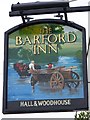
Sign for the Barford Inn
Perhaps this sign is based on Constable's Haywain.
Image: © Maigheach-gheal
Taken: 30 Sep 2007
0.02 miles
9

Barford St Martin: tower of the parish church
Image: © Basher Eyre
Taken: 28 Dec 2013
0.02 miles
