IMAGES TAKEN NEAR TO
Wilton Road, SALISBURY, SP3 4AE
Introduction
This page details the photographs taken nearby to Wilton Road, SP3 4AE by members of the Geograph project.
The Geograph project started in 2005 with the aim of publishing, organising and preserving representative images for every square kilometre of Great Britain, Ireland and the Isle of Man.

There are currently over 7.5m images from over14,400 individuals and you can help contribute to the project by visiting https://www.geograph.org.uk
Image Map
Images are licensed for reuse under creativecommons.org/licenses/by-sa/2.0
Notes
- Clicking on the map will re-center to the selected point.
- The higher the marker number, the further away the image location is from the centre of the postcode.
Image Listing (5 Images Found)
Images are licensed for reuse under creativecommons.org/licenses/by-sa/2.0
Image
Details
Distance
1
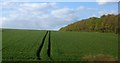
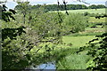
Crop near Barford St Martin
A line of trees forms a shelter belt beside this field on the downs north of the Nadder valley. View from a train on the railway line between Tisbury and Salisbury.
Image: © Derek Harper
Taken: 29 Apr 2013
0.12 miles
2

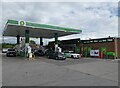
Filling station on A30 east of Barford St Martin
This is now a BP station; formerly it was a Texaco station Image
Image: © David Smith
Taken: 22 Jun 2013
0.18 miles
3
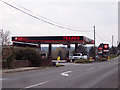
Tinkerbell Service Station, Barford St Martin
Image: © Maigheach-gheal
Taken: 6 Feb 2007
0.18 miles