IMAGES TAKEN NEAR TO
Dareham Mews, SP2 9GE
Introduction
This page details the photographs taken nearby to Dareham Mews, SP2 9GE by members of the Geograph project.
The Geograph project started in 2005 with the aim of publishing, organising and preserving representative images for every square kilometre of Great Britain, Ireland and the Isle of Man.

There are currently over 7.5m images from over14,400 individuals and you can help contribute to the project by visiting https://www.geograph.org.uk
Image Map (Loading...)


Getting Data...Please wait
Leaflet Map data © OpenStreetMap
Images are licensed for reuse under creativecommons.org/licenses/by-sa/2.0
Notes
- Clicking on the map will re-center to the selected point.
- The higher the marker number, the further away the image location is from the centre of the postcode.
Image Listing (9 Images Found)
Images are licensed for reuse under creativecommons.org/licenses/by-sa/2.0
Image
Details
Distance
1
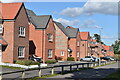
New street scene at Ivie Place
Part of the St Peters Place development (no apostrophe used by the developer), still under active development nearby.
Image: © David Martin
Taken: 8 Oct 2022
0.11 miles
2
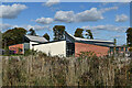
St Peter's CE Primary Academy
Part of the St Peters Place development (no apostrophe used by the developer, but thankfully there is one in name of the school).
Image: © David Martin
Taken: 8 Oct 2022
0.16 miles
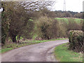
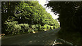
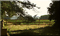
4
By the track to Fugglestone Red Buildings
On the left is Image
Image: © Derek Harper
Taken: 30 Jun 2018
0.18 miles
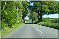
5
The Avenue
Looking in the opposite direction to Image] towards Wilton.
Image: © Derek Harper
Taken: 30 Jun 2018
0.19 miles
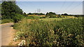
6
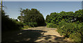
Junction on The Avenue
Taken on the other side of the road from where Image] was taken, with the track shown in Image leaving on the right.
Image: © Derek Harper
Taken: 30 Jun 2018
0.20 miles
7
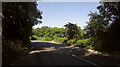
Kingsway
The track shown in Image leaves on the right a few metres ahead.
Image: © Derek Harper
Taken: 30 Jun 2018
0.21 miles
8
A360 Devizes Road
Heading away from Salisbury, ahead is a new roundabout at New Cut Crossroads, associated with further out-of-town housing development.
Image: © Robin Webster
Taken: 30 May 2021
0.22 miles
9
On Camp Hill
Looking left from where Image was taken, with a glimpse of field and woods.
Image: © Derek Harper
Taken: 30 Jun 2018
0.24 miles