IMAGES TAKEN NEAR TO
Wylye Close, SALISBURY, SP2 9BE
Introduction
This page details the photographs taken nearby to Wylye Close, SP2 9BE by members of the Geograph project.
The Geograph project started in 2005 with the aim of publishing, organising and preserving representative images for every square kilometre of Great Britain, Ireland and the Isle of Man.

There are currently over 7.5m images from over14,400 individuals and you can help contribute to the project by visiting https://www.geograph.org.uk
Image Map (Loading...)


Getting Data...Please wait
Leaflet Map data © OpenStreetMap
Images are licensed for reuse under creativecommons.org/licenses/by-sa/2.0
Notes
- Clicking on the map will re-center to the selected point.
- The higher the marker number, the further away the image location is from the centre of the postcode.
Image Listing (39 Images Found)
Images are licensed for reuse under creativecommons.org/licenses/by-sa/2.0
Image
Details
Distance
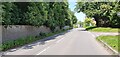
1
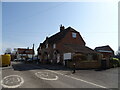
Raised pavement beside Lower Road at Quidhampton
Image: © David Martin
Taken: 4 Feb 2016
0.04 miles
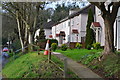
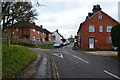
3
The Orange Way in Wiltshire (150)
This is Lower Road in Quidhampton.
Image: © Shazz
Taken: 22 Apr 2013
0.05 miles
5
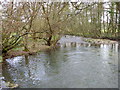
River Wylye, Quidhampton
The Wylye is generally regarded as the most notable of the Avon tributaries.
Image: © Maigheach-gheal
Taken: 22 Mar 2011
0.05 miles
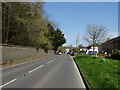
8

Frosty in Quidhampton
A traditional style snowman beside the A3049.
Image: © Maigheach-gheal
Taken: 12 Jan 2010
0.07 miles