IMAGES TAKEN NEAR TO
Wilton Road, SALISBURY, SP2 9AQ
Introduction
This page details the photographs taken nearby to Wilton Road, SP2 9AQ by members of the Geograph project.
The Geograph project started in 2005 with the aim of publishing, organising and preserving representative images for every square kilometre of Great Britain, Ireland and the Isle of Man.

There are currently over 7.5m images from over14,400 individuals and you can help contribute to the project by visiting https://www.geograph.org.uk
Image Map (Loading...)


Getting Data...Please wait
Leaflet Map data © OpenStreetMap
Images are licensed for reuse under creativecommons.org/licenses/by-sa/2.0
Notes
- Clicking on the map will re-center to the selected point.
- The higher the marker number, the further away the image location is from the centre of the postcode.
Image Listing (36 Images Found)
Images are licensed for reuse under creativecommons.org/licenses/by-sa/2.0
Image
Details
Distance
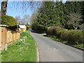
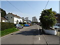
3
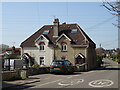
Junction, Quidhampton
Lower Road meets Skew Road coming in from the right, at the east end of the village.
Image: © Derek Harper
Taken: 30 Jun 2018
0.07 miles
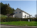
6
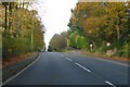
A36 Wilton Road
Heading out of Salisbury.
Image: © Robin Webster
Taken: 13 Nov 2022
0.08 miles
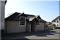
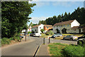
10
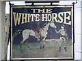
Sign for the White Horse, Quidhampton
This sign has been in use since the fifteenth century and remains very frequent because of its widespread usage.
Image: © Maigheach-gheal
Taken: 2 Aug 2008
0.10 miles