IMAGES TAKEN NEAR TO
Penning Road, SALISBURY, SP2 9AB
Introduction
This page details the photographs taken nearby to Penning Road, SP2 9AB by members of the Geograph project.
The Geograph project started in 2005 with the aim of publishing, organising and preserving representative images for every square kilometre of Great Britain, Ireland and the Isle of Man.

There are currently over 7.5m images from over14,400 individuals and you can help contribute to the project by visiting https://www.geograph.org.uk
Image Map (Loading...)


Getting Data...Please wait
Leaflet Map data © OpenStreetMap
Images are licensed for reuse under creativecommons.org/licenses/by-sa/2.0
Notes
- Clicking on the map will re-center to the selected point.
- The higher the marker number, the further away the image location is from the centre of the postcode.
Image Listing (3 Images Found)
Images are licensed for reuse under creativecommons.org/licenses/by-sa/2.0
Image
Details
Distance
1
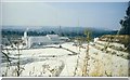
Quidhampton Chalk Quarry
This produces finely ground chalk and marble based products by dry mining and then grinding in water
Image: © mike hancock
Taken: Unknown
0.14 miles
2
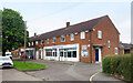
Bemerton Health Centre
Next to a couple of local shops at the end of Pinewood Way
Image: © Des Blenkinsopp
Taken: 28 May 2024
0.20 miles
3
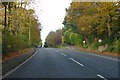
A36 Wilton Road
Heading out of Salisbury.
Image: © Robin Webster
Taken: 13 Nov 2022
0.23 miles