IMAGES TAKEN NEAR TO
West View, SALISBURY, SP2 0QP
Introduction
This page details the photographs taken nearby to West View, SP2 0QP by members of the Geograph project.
The Geograph project started in 2005 with the aim of publishing, organising and preserving representative images for every square kilometre of Great Britain, Ireland and the Isle of Man.

There are currently over 7.5m images from over14,400 individuals and you can help contribute to the project by visiting https://www.geograph.org.uk
Image Map
Images are licensed for reuse under creativecommons.org/licenses/by-sa/2.0
Notes
- Clicking on the map will re-center to the selected point.
- The higher the marker number, the further away the image location is from the centre of the postcode.
Image Listing (20 Images Found)
Images are licensed for reuse under creativecommons.org/licenses/by-sa/2.0
Image
Details
Distance
1
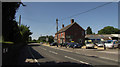
A36 at South Newton
Passing South Newton Industrial Estate on the right.
Image: © Derek Harper
Taken: 30 Jun 2018
0.02 miles
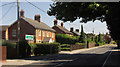
2
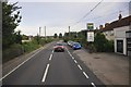
South Newton : The A36
The A36 heading through the village of South Newton in Wiltshire.
Image: © Lewis Clarke
Taken: 23 Aug 2012
0.02 miles
3
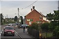
South Newton : The A36
The A36 heading through the Wiltshire village of South Newton.
Image: © Lewis Clarke
Taken: 23 Aug 2012
0.03 miles
4
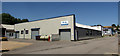
South Newton Industrial Estate
M&M Design and Metalwork occupying a prominent position near the A36 at the north end of the village.
Image: © Derek Harper
Taken: 30 Jun 2018
0.03 miles
5
A36 at South Newton
Looking in the opposite direction from where Image] was taken.
Image: © Derek Harper
Taken: 30 Jun 2018
0.08 miles
6
![South Newton houses [1]](https://s1.geograph.org.uk/geophotos/07/18/15/7181525_d9865612_120x120.jpg)
South Newton houses [1]
Numbers 1 to 4 Pembroke Cottages, Warminster Road, are a row of four estate cottages. Built in 1859, for the Wilton Estate. Constructed of flint and brick bands under a Welsh slate roof. Listed, grade II, with details at: https://historicengland.org.uk/listing/the-list/list-entry/1146218
South Newton is a small village 4 miles northwest of Salisbury in Wiltshire. The village straddles the A36 road on the left bank of the River Wylye. Settled since the Saxon period, South Newton is largely a 10th-century estate. A small light industrial estate, a large building maintenance company and a large neurophysiological rehabilitation nursing home provide significant local employment.
Image: © Michael Dibb
Taken: 20 Apr 2022
0.13 miles
7
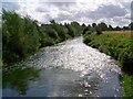
River Wylye near South Newton
Taken from the footbridge to South Newton looking downstream.
Image: © Maigheach-gheal
Taken: 3 Sep 2008
0.15 miles
8
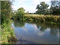
River Wylye near South Newton
The River Wylye contains an excellent stock of mostly wild Brown Trout and Grayling although this is supplemented by some stocking of Brown Trout.
Image: © Maigheach-gheal
Taken: 3 Sep 2008
0.15 miles
9
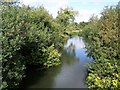
River Wylye near South Newton
Taken from the footbridge looking upstream.
Image: © Maigheach-gheal
Taken: 3 Sep 2008
0.15 miles
10
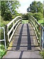
Footbridge over the River Wylye
The footbridge takes walkers over the river on the footpath to South Newton.
Image: © Maigheach-gheal
Taken: 3 Sep 2008
0.16 miles