IMAGES TAKEN NEAR TO
South Newton, SALISBURY, SP2 0QB
Introduction
This page details the photographs taken nearby to SP2 0QB by members of the Geograph project.
The Geograph project started in 2005 with the aim of publishing, organising and preserving representative images for every square kilometre of Great Britain, Ireland and the Isle of Man.

There are currently over 7.5m images from over14,400 individuals and you can help contribute to the project by visiting https://www.geograph.org.uk
Image Map (Loading...)


Getting Data...Please wait
Leaflet Map data © OpenStreetMap
Images are licensed for reuse under creativecommons.org/licenses/by-sa/2.0
Notes
- Clicking on the map will re-center to the selected point.
- The higher the marker number, the further away the image location is from the centre of the postcode.
Image Listing (20 Images Found)
Images are licensed for reuse under creativecommons.org/licenses/by-sa/2.0
Image
Details
Distance
1
Wandering westwards along the Bashire (80)
Looking from Mill Farm Lane down towards a car heading south-southeast on the A36
Image: © Basher Eyre
Taken: 13 Aug 2023
0.09 miles
2
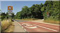
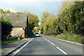
A36 entering South Newton
The start of the 30mph zone as the main road passes the turn on the right to Mill Farm.
Image: © Derek Harper
Taken: 30 Jun 2018
0.11 miles
3
Hedge by Mill Farm
Seen across the A36 a few metres south from the scene in Image
Image: © Derek Harper
Taken: 30 Jun 2018
0.11 miles
4
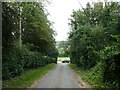
Junction, Mill Farm
The no through lane from the farm and from restricted byway SNEW 9 meets the A36, with a glimpse across the Wylye valley.
Image: © Derek Harper
Taken: 30 Jun 2018
0.11 miles
5
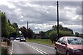
A36 by South Milton Mill
The barn seems to have been to do with the mill.
Image: © Robin Webster
Taken: 13 Nov 2022
0.12 miles
6
A36 leaving South Newton
Heading South.
Image: © Julian P Guffogg
Taken: 12 Aug 2013
0.13 miles
7
South Newton Mill
Looking right from where Image] was taken.
Image: © Derek Harper
Taken: 30 Jun 2018
0.14 miles
8
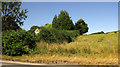
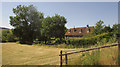
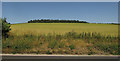
Salisbury District : Grassy Field & Hillside
A small sloping hillside near South Newton in Wiltshire.
Image: © Lewis Clarke
Taken: 28 Aug 2012
0.14 miles
9
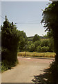
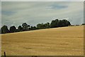
Field by the A36
Looking more to the left from where Image] was taken. The wood on the horizon is 400 metres from left to right, but just 100 metres deep.
Image: © Derek Harper
Taken: 30 Jun 2018
0.15 miles
10
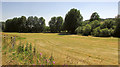
Field near South Newton Mill
From the A36. The trees line the River Wylye.
Image: © Derek Harper
Taken: 30 Jun 2018
0.17 miles