IMAGES TAKEN NEAR TO
Stoford, SALISBURY, SP2 0PN
Introduction
This page details the photographs taken nearby to SP2 0PN by members of the Geograph project.
The Geograph project started in 2005 with the aim of publishing, organising and preserving representative images for every square kilometre of Great Britain, Ireland and the Isle of Man.

There are currently over 7.5m images from over14,400 individuals and you can help contribute to the project by visiting https://www.geograph.org.uk
Image Map (169 Images)


Getting Data...Please wait
Leaflet Map data © OpenStreetMap
Images are licensed for reuse under creativecommons.org/licenses/by-sa/2.0
Notes
- Clicking on the map will re-center to the selected point.
- The higher the marker number, the further away the image location is from the centre of the postcode.
Image Listing (169 Images Found)
Images are licensed for reuse under creativecommons.org/licenses/by-sa/2.0
Image
Details
Distance
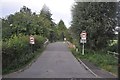
2
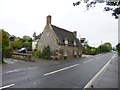
Stoford, Charity Farmhouse
On Warminster Road.
Image: © Mike Faherty
Taken: 3 Oct 2013
0.05 miles
3
![Great Wishford features [12]](https://s1.geograph.org.uk/geophotos/07/18/33/7183389_0f8555e0_120x120.jpg)
Great Wishford features [12]
The River Wylye, looking downstream from Stoford Bridge.
Great Wishford is a village in the valley of the River Wylye in Wiltshire, some 6 miles northwest of Salisbury. The village was settled in the Saxon period and was known as Wicheford (meaning a ford where wych-elms grow). Great Wishford celebrates Oak Apple Day on the 29th of May each year, when villagers claim their ancient rights to collect wood from Grovely Wood. The tradition is said to date back to 1603.
Image: © Michael Dibb
Taken: 20 Apr 2022
0.05 miles
4
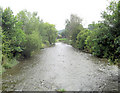
River Wylye from Stoford Bridge
Looking downstream.
Image: © Stuart Logan
Taken: 26 Jul 2011
0.06 miles
5

River Wylye from Stoford Bridge
Looking downstream, with much water crowfoot in evidence.
Image: © Derek Harper
Taken: 30 Jun 2018
0.07 miles
6
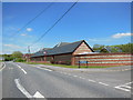
Modern building in Stoford
The wall has been built in the traditional style with courses of brick and flint. There are a few modern houses on the right screened by this one
Image: © David Smith
Taken: 26 Jun 2013
0.08 miles
7
![Great Wishford features [10]](https://s3.geograph.org.uk/geophotos/07/18/33/7183387_4149ecb9_120x120.jpg)
Great Wishford features [10]
From West Street this path, not a Right of Way, gives access to the river bank for the anglers of The Wilton Club.
Great Wishford is a village in the valley of the River Wylye in Wiltshire, some 6 miles northwest of Salisbury. The village was settled in the Saxon period and was known as Wicheford (meaning a ford where wych-elms grow). Great Wishford celebrates Oak Apple Day on the 29th of May each year, when villagers claim their ancient rights to collect wood from Grovely Wood. The tradition is said to date back to 1603.
Image: © Michael Dibb
Taken: 20 Apr 2022
0.08 miles
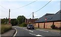
8
Stoford : West Street
West Street in Stoford where it heads across the River Wylye.
Image: © Lewis Clarke
Taken: 23 Aug 2012
0.09 miles
9
![Great Wishford features [11]](https://s0.geograph.org.uk/geophotos/07/18/33/7183388_7983b482_120x120.jpg)
Great Wishford features [11]
Stoford Bridge carries West Street over the River Wylye. Originally built in the early 18th century and rebuilt in 1841. Constructed in limestone with a brick parapet. There are five segmental ashlar arches with keystones and cutwaters. The keystone at the centre of the north side is inscribed 'REBUILT By PLOWMAN AND MAY 1841. Listed, grade II, with details at: https://historicengland.org.uk/listing/the-list/list-entry/1146252
Great Wishford is a village in the valley of the River Wylye in Wiltshire, some 6 miles northwest of Salisbury. The village was settled in the Saxon period and was known as Wicheford (meaning a ford where wych-elms grow). Great Wishford celebrates Oak Apple Day on the 29th of May each year, when villagers claim their ancient rights to collect wood from Grovely Wood. The tradition is said to date back to 1603.
Image: © Michael Dibb
Taken: 20 Apr 2022
0.09 miles
10
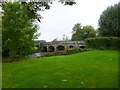
Stoford Bridge
C18 stone bridge with brick parapet over River Wylye; listed by English Heritage: http://www.imagesofengland.org.uk/Details/Default.aspx?id=320466&mode=adv
Image: © Mike Faherty
Taken: 3 Oct 2013
0.09 miles