IMAGES TAKEN NEAR TO
St. Johns Court, SALISBURY, SP2 0EU
Introduction
This page details the photographs taken nearby to St. Johns Court, SP2 0EU by members of the Geograph project.
The Geograph project started in 2005 with the aim of publishing, organising and preserving representative images for every square kilometre of Great Britain, Ireland and the Isle of Man.

There are currently over 7.5m images from over14,400 individuals and you can help contribute to the project by visiting https://www.geograph.org.uk
Image Map (Loading...)


Getting Data...Please wait
Leaflet Map data © OpenStreetMap
Images are licensed for reuse under creativecommons.org/licenses/by-sa/2.0
Notes
- Clicking on the map will re-center to the selected point.
- The higher the marker number, the further away the image location is from the centre of the postcode.
Image Listing (268 Images Found)
Images are licensed for reuse under creativecommons.org/licenses/by-sa/2.0
Image
Details
Distance
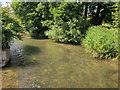
1
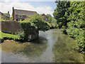
Butcher's Brook, Wilton
Another view upstream like Image], from further across the footbridge. The houses are on St John's Court.
Image: © Derek Harper
Taken: 19 Jun 2014
0.01 miles
2
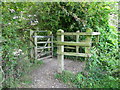
Kissing gate, Flouse Hole
The kissing gate is a traditional gate hung in a U or V shape that allows one person to pass at a time. In order for one person to pass fully through the gate they have to close it on the next person. Legend has it that at this point, when the two are on either side of the gate, the person in front ‘refuses’ entry to the second person until presented with a kiss.
Image: © Maigheach-gheal
Taken: 24 Aug 2011
0.02 miles
3
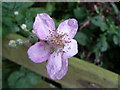
Blackberry flower, Flouse Hole
The flowers can be white to deep pink in colour and most forms of the flowers have a pleasant scent. The flowers fade in late summer to produce fruits which are green at first, changing to red and being fully ripe when they turn deep purple to black.
Image: © Maigheach-gheal
Taken: 24 Aug 2011
0.02 miles
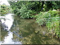
4
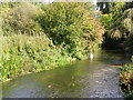
Butchers Brook, Wilton
Butchers Brook is one of the many channels of the River Wylye flowing behind homes in West Street.
Looking downstream.
Image: © Maigheach-gheal
Taken: 24 Aug 2011
0.02 miles
5
Butcher's Brook, Wilton
Image: © Derek Harper
Taken: 19 Jun 2014
0.02 miles
6
Butchers Brook, Wilton
Butchers Brook is one of the many channels of the River Wylye flowing behind homes in West Street.
Looking upstream.
Image: © Maigheach-gheal
Taken: 24 Aug 2011
0.02 miles
7
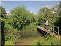
Butcher's Brook, Wilton
This southern channel of the River Wylye is referred to as "Butcher's Brook" at Image, and I'm happy to re-use the name, though I can't find it on any maps. The path (WILT 14) leads into Flouse Hole Nature Reserve.
Image: © Derek Harper
Taken: 19 Jun 2014
0.03 miles
8
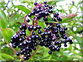
Elderberries, Flouse Hole
The elder branches have become heavy with bunches of lustrous black juicy fruits. Insipid when raw, they make a distinctively flavoured wine and are also used in pies and jellies.
Image: © Maigheach-gheal
Taken: 24 Aug 2011
0.03 miles
9
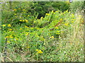
Golden Rod (Solidago virgaurea), Flouse Hole
As its generic name which comes from solidare (to consolidate or make whole) indicates, golden rod has a reputation for healing wounds when applied as a poultice or used as an infusion to bathe the wound.
Image: © Maigheach-gheal
Taken: 24 Aug 2011
0.03 miles
10
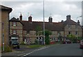
Eye-catching front wall of houses in Wilton
These are opposite St John's Priory, on a bend in the A30
Image: © David Smith
Taken: 22 Jun 2013
0.03 miles