IMAGES TAKEN NEAR TO
Victoria Road, SALISBURY, SP2 0DY
Introduction
This page details the photographs taken nearby to Victoria Road, SP2 0DY by members of the Geograph project.
The Geograph project started in 2005 with the aim of publishing, organising and preserving representative images for every square kilometre of Great Britain, Ireland and the Isle of Man.

There are currently over 7.5m images from over14,400 individuals and you can help contribute to the project by visiting https://www.geograph.org.uk
Image Map
Images are licensed for reuse under creativecommons.org/licenses/by-sa/2.0
Notes
- Clicking on the map will re-center to the selected point.
- The higher the marker number, the further away the image location is from the centre of the postcode.
Image Listing (75 Images Found)
Images are licensed for reuse under creativecommons.org/licenses/by-sa/2.0
Image
Details
Distance
1
![Wilton houses [24]](https://s0.geograph.org.uk/geophotos/07/04/63/7046352_2a2e6065_120x120.jpg)
Wilton houses [24]
Number 50 Shaftesbury Road was built in the mid 19th century. The front is brick, the rest flint with brick lacing, all under a thatch roof. Listed, grade II, with details at: https://historicengland.org.uk/listing/the-list/list-entry/1199079
A former county town, Wilton is situated some 2¾ miles west of Salisbury on the confluence of the River Nadder and the River Wylye. The town grew around Wilton Abbey, founded in the 8th century, and was the administrative capital of Wiltshire until the 11th century. The town declined in importance after Salisbury Cathedral was built. The town is renowned for carpet manufacture, which began in 1741 when two French weavers were brought in and a carpet factory continued to operate until 1995. The country estate of Wilton House is an integral part of the town.
Image: © Michael Dibb
Taken: 25 Aug 2021
0.04 miles

3
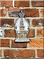
Firemark, 50 Shaftesbury Road
The firemark is attached to Image
Firemarks originated around the late 17th century at which time insurance companies operated their own fire brigades to protect insured property. As many buildings did not have a formal address until the advent of the postal system, insurance companies identified insured properties by placing a mark on the outside wall of the buildings.
Image: © Maigheach-gheal
Taken: 21 Oct 2011
0.05 miles
4
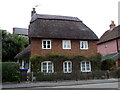
Thatched cottage, Shaftesbury Road
The cottage stands beside the A30, Shaftesbury Road and it has a firemark over the middle window of the lower floor.
Image: © Maigheach-gheal
Taken: 21 Oct 2011
0.05 miles
5
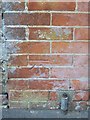
Bench Mark, Shaftesbury Road
The bench mark is on the wall of No 64, Shaftesbury Road. For a wider view see Image and http://www.bench-marks.org.uk/bm34298
A bench mark is an Ordnance Survey arrowhead sign found on walls, bridges, churches and specially erected triangulation pillars where the altitude above sea-level has been accurately measured by surveyors. The arrowhead points to a horizontal line above it which marks the exact altitude.
With rivets and pivots there is no datum (horizontal line) cut, the pointed-to horizontal surface defining the datum height.
Image: © Maigheach-gheal
Taken: 11 May 2010
0.06 miles
6
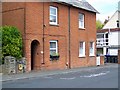
Housing on Shaftesbury Road
Brick built semi-detached homes on the A30, Shaftesbury Road. There is a bench mark on the wall between the hydrant and the door.
Image: © Maigheach-gheal
Taken: 11 May 2010
0.07 miles
7
![Wilton houses [23]](https://s3.geograph.org.uk/geophotos/07/04/63/7046351_d69ce84e_120x120.jpg)
Wilton houses [23]
Numbers 37, 39 and 41 Shaftesbury Road are a row of three 18th century cottages. Constructed of plastered cob on a brick plinth, under a thatch roof. Listed, grade II, with details at: https://historicengland.org.uk/listing/the-list/list-entry/1023736
A former county town, Wilton is situated some 2¾ miles west of Salisbury on the confluence of the River Nadder and the River Wylye. The town grew around Wilton Abbey, founded in the 8th century, and was the administrative capital of Wiltshire until the 11th century. The town declined in importance after Salisbury Cathedral was built. The town is renowned for carpet manufacture, which began in 1741 when two French weavers were brought in and a carpet factory continued to operate until 1995. The country estate of Wilton House is an integral part of the town.
Image: © Michael Dibb
Taken: 25 Aug 2021
0.07 miles
9
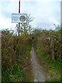
The Orange Way in Wiltshire (137)
Here's no public right of way in Ditchampton.
Image: © Shazz
Taken: 22 Apr 2013
0.08 miles