IMAGES TAKEN NEAR TO
Kingsbury Square, SALISBURY, SP2 0BA
Introduction
This page details the photographs taken nearby to Kingsbury Square, SP2 0BA by members of the Geograph project.
The Geograph project started in 2005 with the aim of publishing, organising and preserving representative images for every square kilometre of Great Britain, Ireland and the Isle of Man.

There are currently over 7.5m images from over14,400 individuals and you can help contribute to the project by visiting https://www.geograph.org.uk
Image Map
Images are licensed for reuse under creativecommons.org/licenses/by-sa/2.0
Notes
- Clicking on the map will re-center to the selected point.
- The higher the marker number, the further away the image location is from the centre of the postcode.
Image Listing (447 Images Found)
Images are licensed for reuse under creativecommons.org/licenses/by-sa/2.0
Image
Details
Distance
1
![Wilton houses [49]](https://s3.geograph.org.uk/geophotos/07/04/82/7048203_4f73b1a7_120x120.jpg)
Wilton houses [49]
Number 4 Kingsbury Square is an early 19th century house. Built in brick which is chequered to the first floor and which has been much altered to the ground floor, all under a hipped slate roof. Listed, grade II, with details at: https://historicengland.org.uk/listing/the-list/list-entry/1023709
A former county town, Wilton is situated some 2¾ miles west of Salisbury on the confluence of the River Nadder and the River Wylye. The town grew around Wilton Abbey, founded in the 8th century, and was the administrative capital of Wiltshire until the 11th century. The town declined in importance after Salisbury Cathedral was built. The town is renowned for carpet manufacture, which began in 1741 when two French weavers were brought in and a carpet factory continued to operate until 1995. The country estate of Wilton House is an integral part of the town.
Image: © Michael Dibb
Taken: 25 Aug 2021
0.00 miles
3
Wilton - Minster Street
Attractive street straddling a green between Wilton town centre and Wilton House.
Image: © Colin Smith
Taken: 25 Mar 2022
0.00 miles
4
Wilton - Minster Street
Attractive street straddled by a green between Wilton town centre and Wilton House.
Image: © Colin Smith
Taken: 25 Mar 2022
0.00 miles
5
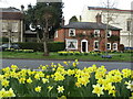
The Old Manse, Wilton
The Old Manse stands on Kingsbury Square.
Image: © Maigheach-gheal
Taken: 6 Mar 2012
0.01 miles
6
Firemark, Wilton
The firemark is attached to the Old Manse and for a wider view Image
Firemarks originated around the late 17th century at which time insurance companies operated their own fire brigades to protect insured property. As many buildings did not have a formal address until the advent of the postal system, insurance companies identified insured properties by placing a mark on the outside wall of the buildings.
Image: © Maigheach-gheal
Taken: 6 Mar 2012
0.01 miles
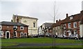
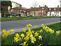
7
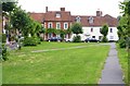
Houses on Kingsbury Square, Wilton
This square, which comprises a green diagonally bisected by the A30 road, has many fine old buildings around the edge.
Image: © mike smith
Taken: 10 Aug 2013
0.01 miles
8
![Wilton buildings [24]](https://s0.geograph.org.uk/geophotos/07/04/82/7048212_585d7f30_120x120.jpg)
Wilton buildings [24]
This large building at number 5 Kingsbury Square was constructed in 1880 as a Primitive Methodist chapel. In the 1980s it became the Catholic Church of St Edith and now also accommodates the Methodists and the United Reformed Church. Built of stuccoed brick, with a palazzo front under heavy Doric entablature with a hipped slate roof. Listed, grade II, with details at: https://historicengland.org.uk/listing/the-list/list-entry/1023710
A former county town, Wilton is situated some 2¾ miles west of Salisbury on the confluence of the River Nadder and the River Wylye. The town grew around Wilton Abbey, founded in the 8th century, and was the administrative capital of Wiltshire until the 11th century. The town declined in importance after Salisbury Cathedral was built. The town is renowned for carpet manufacture, which began in 1741 when two French weavers were brought in and a carpet factory continued to operate until 1995. The country estate of Wilton House is an integral part of the town.
Image: © Michael Dibb
Taken: 25 Aug 2021
0.01 miles
9
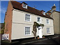
Wool House, Wilton
Wool House stands on Kingsbury Square and has an insurance fire plate displayed on the front.
Image: © Maigheach-gheal
Taken: 19 Nov 2010
0.02 miles
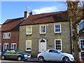
10
![Wilton houses [51]](https://s3.geograph.org.uk/geophotos/07/04/82/7048219_6e7f639f_120x120.jpg)
Wilton houses [51]
Number 8 Kingsbury Square was built in the mid 18th century. Constructed of red brick on a stone plinth with stone quoins and voussoir lintels, all under a tile roof. Some original internal features and fittings remain. Listed, grade II, with details at: https://historicengland.org.uk/listing/the-list/list-entry/1355779
A former county town, Wilton is situated some 2¾ miles west of Salisbury on the confluence of the River Nadder and the River Wylye. The town grew around Wilton Abbey, founded in the 8th century, and was the administrative capital of Wiltshire until the 11th century. The town declined in importance after Salisbury Cathedral was built. The town is renowned for carpet manufacture, which began in 1741 when two French weavers were brought in and a carpet factory continued to operate until 1995. The country estate of Wilton House is an integral part of the town.
Image: © Michael Dibb
Taken: 25 Aug 2021
0.02 miles