IMAGES TAKEN NEAR TO
Chilhampton, SALISBURY, SP2 0AD
Introduction
This page details the photographs taken nearby to Chilhampton, SP2 0AD by members of the Geograph project.
The Geograph project started in 2005 with the aim of publishing, organising and preserving representative images for every square kilometre of Great Britain, Ireland and the Isle of Man.

There are currently over 7.5m images from over14,400 individuals and you can help contribute to the project by visiting https://www.geograph.org.uk
Image Map (Loading...)


Getting Data...Please wait
Leaflet Map data © OpenStreetMap
Images are licensed for reuse under creativecommons.org/licenses/by-sa/2.0
Notes
- Clicking on the map will re-center to the selected point.
- The higher the marker number, the further away the image location is from the centre of the postcode.
Image Listing (10 Images Found)
Images are licensed for reuse under creativecommons.org/licenses/by-sa/2.0
Image
Details
Distance
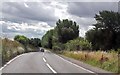
1
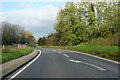
Bends on the A36
Towards Warminster and Bath.
Image: © Robin Webster
Taken: 13 Nov 2022
0.02 miles
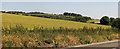
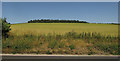
2
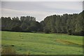
Salisbury District : Grassy Field
A grassy field as seen from the A36 in Wiltshire.
Image: © Lewis Clarke
Taken: 23 Aug 2012
0.05 miles
3
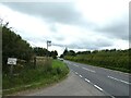
Wandering westwards along the Bashire (79)
Folly Farm bus stop on the A36
Image: © Basher Eyre
Taken: 13 Aug 2023
0.09 miles
4
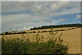
Salisbury District : Grassy Field
Looking towards a grassy field beyond the bush.
Image: © Lewis Clarke
Taken: 28 Aug 2012
0.09 miles
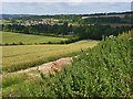
6
Farmland by the A36
See Image], which shows some of the features on the right. The land climbs from the Wylye valley.
Image: © Derek Harper
Taken: 30 Jun 2018
0.14 miles
7
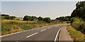
A36 south of South Newton
Approaching White Cottages, just left of centre.
Image: © Derek Harper
Taken: 30 Jun 2018
0.19 miles
8
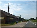
Farm shop and cafe by A36 in Chilhampton
A fine barn beside the road, with courses of brick and flint
Image: © David Smith
Taken: 26 Jun 2013
0.21 miles
9
Farmland, Chilhampton
Looking down on Chilhampton Farm from Folly Farm. Beyond are houses in Ditchampton.
Image: © Andrew Smith
Taken: 7 Jul 2007
0.24 miles
10
Field by the A36
Looking more to the left from where Image] was taken. The wood on the horizon is 400 metres from left to right, but just 100 metres deep.
Image: © Derek Harper
Taken: 30 Jun 2018
0.24 miles