IMAGES TAKEN NEAR TO
Milford Hill, SALISBURY, SP1 2QX
Introduction
This page details the photographs taken nearby to Milford Hill, SP1 2QX by members of the Geograph project.
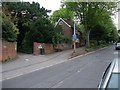
The Geograph project started in 2005 with the aim of publishing, organising and preserving representative images for every square kilometre of Great Britain, Ireland and the Isle of Man.

There are currently over 7.5m images from over14,400 individuals and you can help contribute to the project by visiting https://www.geograph.org.uk
Image Map
Images are licensed for reuse under creativecommons.org/licenses/by-sa/2.0
Notes
- Clicking on the map will re-center to the selected point.
- The higher the marker number, the further away the image location is from the centre of the postcode.
Image Listing (223 Images Found)
Images are licensed for reuse under creativecommons.org/licenses/by-sa/2.0
Image
Details
Distance
1
Milford Hill, Salisbury
The entrance to Salisbury Youth Hostel, and start of our walk along the Clarendon Way to Winchester
Image: © Tim Heaton
Taken: 9 May 2010
0.01 miles
2
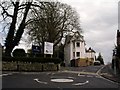
Shady Bower and the Godolphin School, Salisbury
The quaintly named Shady Bower is the road descending the hill (where the car is) from the mini-roundabout. The grounds of the Godolphin School are on the left.
Image: © Peter Jordan
Taken: 14 Apr 2006
0.01 miles
3
Salisbury Youth Hostel
The leafy entrance to the hostel, which is a fine villa over 200 years old and set in its own private grounds.
Image: © Neil Owen
Taken: 16 May 2012
0.01 miles
4
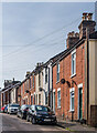
Salisbury, Milford Hill
Houses on Milford Hill.
Image: © David Dixon
Taken: 15 Jul 2017
0.01 miles
5
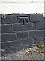
Benchmark in Fowler's Road
A cutmark on the brickwork of a housing terrace. See http://www.bench-marks.org.uk/bm44392 for the entry in the Benchmark Database and Image] for a view along the street.
Image: © Neil Owen
Taken: 16 May 2012
0.05 miles
6
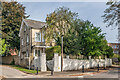
Milford Hill Cottage
Cottage on Milford Hill marked on the 1880 1:500 town plan.
Image: © Ian Capper
Taken: 22 Sep 2022
0.05 miles
7
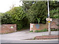
Fowler's Road
A quiet street near the centre of Salisbury and the Youth Hostel. A cutmark has been made on the lefthand side of the terrace - see Image] for a better look.
Image: © Neil Owen
Taken: 16 May 2012
0.05 miles
8
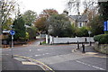
Mini roundabout near entrance to Godolphin School
View from Shady Bower to cross roads: left is Milford Hill, ahead is Bellamy Lane, right is Laverstock Road.
Image: © Roger Templeman
Taken: 5 Nov 2011
0.05 miles
9
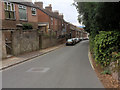
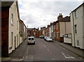
Fowler's Road
Late 19th Century terrace off Milford Hill.
Image: © Ian Capper
Taken: 22 Sep 2022
0.05 miles
10
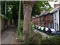
Milford Hill, Salisbury
A terrace climbs the hill on one side of the street, whilst on the other side a path runs behind trees.
Image: © Derek Harper
Taken: 10 Jul 2009
0.05 miles