IMAGES TAKEN NEAR TO
Rampart Road, SALISBURY, SP1 1HZ
Introduction
This page details the photographs taken nearby to Rampart Road, SP1 1HZ by members of the Geograph project.
The Geograph project started in 2005 with the aim of publishing, organising and preserving representative images for every square kilometre of Great Britain, Ireland and the Isle of Man.

There are currently over 7.5m images from over14,400 individuals and you can help contribute to the project by visiting https://www.geograph.org.uk
Image Map (Loading...)


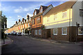
Getting Data...Please wait
Leaflet Map data © OpenStreetMap
Images are licensed for reuse under creativecommons.org/licenses/by-sa/2.0
Notes
- Clicking on the map will re-center to the selected point.
- The higher the marker number, the further away the image location is from the centre of the postcode.
Image Listing (499 Images Found)
Images are licensed for reuse under creativecommons.org/licenses/by-sa/2.0
Image
Details
Distance
1
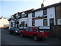
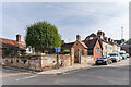
Salisbury - Winchester Gate Public House
The Winchester Gate public house on Rampart Road.
Image: © Chris Talbot
Taken: 30 Mar 2012
0.01 miles
2
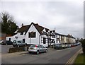
Salisbury, Winchester Gate
2013 Good Beer Guide-listed pub on Rampart Road; left, stage for live music, darts; right, eating and drinking area with pool, TV and games machine; garden. Cask ales on offer at my visit: Goffs Jouster, Hopback Crop Circle & JPA, Stonehenge Danish Dynamite. For some customer comments, see http://www.beerintheevening.com/pubs/s/67/6771/Winchester_Gate/Salisbury
Image: © Mike Faherty
Taken: 14 Apr 2013
0.02 miles
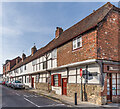
3
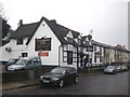
The Winchester Gate public house in Rampart Road
Grade II* Listed as The London Road Inn https://historicengland.org.uk/listing/the-list/list-entry/1023693 . C16th/17th and later altered. Presumably re-named after a gateway in the old city ramparts in this location.
Image: © Rod Allday
Taken: 7 Mar 2013
0.02 miles
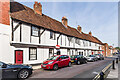
5
Blechynden's Almshouses
Almshouses on Winchester Street on its junction with Greencroft Street, founded in 1683 by Margaret Blechynden and rebuilt in 1857. Grade II listed - see https://historicengland.org.uk/listing/the-list/list-entry/1243412?section=official-list-entry.
Image: © Ian Capper
Taken: 22 Sep 2022
0.05 miles
6
Salisbury, Blechyndens Almshouses
At the corner of Winchester Street & Greencroft Street. http://www.housingcare.org/housing-care/facility-info-8790-blechyndens-almshouses-city-cnetre-england.aspx
Image: © Mike Faherty
Taken: 14 Apr 2013
0.05 miles
7
2 - 14 Guilder Lane
Mid 15th Century terrace. Grade II listed - see https://historicengland.org.uk/listing/the-list/list-entry/1242209?section=official-list-entry.
Image: © Ian Capper
Taken: 22 Sep 2022
0.05 miles
8
2 - 14 Guilder Lane
Mid 15th Century terrace. Grade II listed - see https://historicengland.org.uk/listing/the-list/list-entry/1242209?section=official-list-entry.
Image: © Ian Capper
Taken: 22 Sep 2022
0.05 miles
10
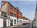
16 - 18 Guilder Lane
Former corn mill in Guilder Lane, now the premises of a printing company. Beyond are nos 2 - 14, a mid 15th Century terrace. Grade II listed - see https://historicengland.org.uk/listing/the-list/list-entry/1242209?section=official-list-entry.
Image: © Ian Capper
Taken: 22 Sep 2022
0.06 miles